
Rayakottai
Rayakottai, also spelled Rayakotta is a town in Denkanikottai taluk, Krishnagiri District, Tamil Nadu, India.[1][2] It is 73 kilometres (45 mi) from Bangalore.[3]
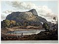
Rayakottai fort
The fort was built by King Krishna deverayar and situated within the town of Rayakottai which is one of the ancient fortress in the Krishnagiri district. It is now one of the protected monument by the Archaeological Survey of India. In the 18th century Hyder Ali and Tipu sultan captured this fort. The fort was captured by Major Gowdie during the third Anglo-Mysore War in 1791. According to the Treaty of Srirangapatna, this fort came into the hands of the British.
Transport
The nearest airport is Bangalore International Airport
The nearest railway station is Rayakottai railway station
The nearest bus stand is Rayakottai Bus Stand
Gallery
-
”Rayakottai Fort”
Henry Salt -

”Rayakottai Fort”
Thomas Daniell


References
2.Government's Krishnagiri District website
3.[1]