
Mokrosuky
Mokrosuky | |
|---|---|
Municipality | |
 | |
 Flag  Coat of arms | |
 Mokrosuky | |
| Coordinates: 49°16′38″N 13°27′14″E / 49.27722°N 13.45389°E | |
| Country | |
| Region | Plzeň |
| District | Klatovy |
| Area | |
| • Total | 6.97 km2 (2.69 sq mi) |
| Elevation | 532 m (1,745 ft) |
| Population (1.1.2015) | |
| • Total | 133 |
| • Density | 19/km2 (49/sq mi) |
| Postal code | 342 01 |
| Website | http://mokrosuky.sumava.net/ou |
Mokrosuky is a village and municipality (obec) in Klatovy District in the Plzeň Region of the Czech Republic.
The municipality covers an area of 6.97 square kilometres (2.69 sq mi), and has a population of 136 (as at 28 August 2006).
Mokrosuky lies approximately 19 kilometres (12 mi) south-east of Klatovy, 53 km (33 mi) south of Plzeň, and 114 km (71 mi) south-west of Prague.
Gallery
-
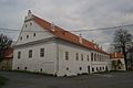 Zámek
Zámek -
 Sloup se sochou
 -
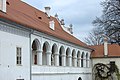 Kolonáda na zámku


References
Wikimedia Commons has media related to Mokrosuky.
| Authority control databases: National |
|---|
This Plzeň Region location article is a stub. You can help Wikipedia by expanding it. |