Most pri Bratislave
Appearance
This article needs additional citations for verification. (February 2013) |
Most pri Bratislave | |
|---|---|
Municipality | |
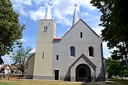
 Church of the Sacred Heart | |
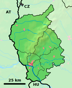
Location of Most pri Bratislave in the Bratislava Region | |
| Coordinates: 48°08′27″N 17°16′10″E / 48.14083°N 17.26944°E | |
| Country | Slovakia |
| Region | Bratislava |
| District | Senec |
| First mentioned | 1283 |
| Area | |
| • Total | 19.01 km2 (7.34 sq mi) |
| Elevation | 130 m (430 ft) |
| Population (2011) | |
| • Total | 2,144 |
| • Density | 110/km2 (290/sq mi) |
| Postal code | 900 32 |
| Area code | 421-2 |
| Car plate | SC |
| Website | www.mostpribratislave.sk |
Most pri Bratislave (Hungarian: Dunahidas, German: Bruck) is a village and municipality in western Slovakia in Senec District in the Bratislava Region.
History
In historical records the village was first mentioned in 1283. Until their expulsion in 1945 the village was inhabited by Germans.
Geography
The municipality lies at an altitude of 130 metres above sea level and covers an area of 19.01 km².
Demographics
According to the 2011 census, the municipality had 2,144 inhabitants. 1,883 of inhabitants were Slovaks, 41 Hungarians, 20 Czechs and 200 others and unspecified.[1]
References
External links/Sources
![]() Media related to Most pri Bratislave at Wikimedia Commons
Media related to Most pri Bratislave at Wikimedia Commons
- Official page
- https://web.archive.org/web/20070513023228/http://www.statistics.sk/mosmis/eng/run.html


