
Obytce
Obytce | |
|---|---|
Municipality | |
 | |
 Flag  Coat of arms | |
 Obytce | |
| Coordinates: 49°23′35″N 13°22′44″E / 49.39306°N 13.37889°E | |
| Country | |
| Region | Plzeň |
| District | Klatovy |
| Area | |
| • Total | 4.37 km2 (1.69 sq mi) |
| Elevation | 490 m (1,610 ft) |
| Population (1.1.2015) | |
| • Total | 211 |
| • Density | 48/km2 (130/sq mi) |
| Postal code | 339 01 |
Obytce is a village and municipality (obec) in Klatovy District in the Plzeň Region of the Czech Republic.
The municipality covers an area of 4.37 square kilometres (1.69 sq mi), and has a population of 171 (as at 3 July 2006).
Obytce lies approximately 7 kilometres (4 mi) east of Klatovy, 40 km (25 mi) south of Plzeň, and 108 km (67 mi) south-west of Prague.
Gallery
-
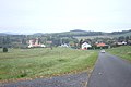 View of the village
 -
 Memorial
 -
 House
House


.jpg)
References
Wikimedia Commons has media related to Obytce.
| Authority control databases: National |
|---|
This Plzeň Region location article is a stub. You can help Wikipedia by expanding it. |