Pasohlávky
Pasohlávky | |
|---|---|
Municipality | |
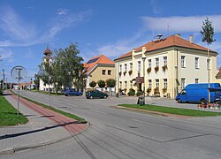
 Main street with municipal office | |
| Coordinates: 48°54′10″N 16°33′32″E / 48.90278°N 16.55889°E | |
| Country | |
| Region | South Moravian |
| District | Brno-Country |
| Government | |
| • Mayor | Martina Dominová (Moravané) |
| Area | |
| • Total | 26.59 km2 (10.27 sq mi) |
| Elevation | 175 m (574 ft) |
| Population (2014) | |
| • Total | 727 |
| • Density | 27/km2 (71/sq mi) |
| Postal code | 691 22 |
| Website | http://www.pasohlavky.cz/ |
Pasohlávky (German: Weißstätten) is a village in South Moravian Region, Czech Republic. It is located 13 km northwest of Mikulov and has a population of 726. Pasohlávky is a popular summer resort on the northern shore of Nové Mlýny I reservoir.
In the cadastral area of Mušov (flooded by the dam and merged into Pasohlávky in late 1970s) there is an important archaeological site, where remains of a permanent Roman fortress from 2nd century have been explored.
External links
Wikimedia Commons has media related to Pasohlávky.


