
Pila (Karlovy Vary District)
Pila | |
|---|---|
Municipality and village | |
 Upper part of the village | |
 Flag  Coat of arms | |
 | |
 Pila Location in the Czech Republic | |
| Coordinates: 50°10′48″N 12°55′33″E / 50.18°N 12.9258°E | |
| Country | |
| Region | Karlovy Vary Region |
| District | Karlovy Vary District |
| Area | |
| • Total | 2.7 sq mi (7.1 km2) |
| Elevation | 1,800 ft (550 m) |
| Population (2011) | |
| • Total | 460 |
| Time zone | UTC+1 (CET) |
| • Summer (DST) | UTC+2 (CEST) |
Pila (German: Schneidmühl) is a village and municipality in Karlovy Vary District in the Karlovy Vary Region of the Czech Republic. The municipality covers an area of 7.1 square kilometres (2.7 sq mi) and as of 2006 it had a population of 461.
Gallery
-
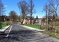 A bridge over Lomnický Creek in Pila
 -
 Bus stop
 -
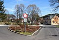
 Lower part of Pila
 -
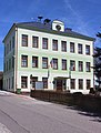 Municipal office


Wikimedia Commons has media related to Pila (Karlovy Vary District).
| Authority control databases: National |
|---|
This Karlovy Vary Region location article is a stub. You can help Wikipedia by expanding it. |