Vacov
Appearance
Vacov | |
|---|---|
Village | |
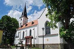
 Church of Saint Nicholas | |
| Coordinates: 49°08′10″N 13°43′47″E / 49.13611°N 13.72972°E | |
| Country | Czech Republic |
| Region | South Bohemian |
| District | Prachatice |
| First mentioned | 1352 |
| Government | |
| • Mayor | Miroslav Roučka |
| Area | |
| • Total | 35.21 km2 (13.59 sq mi) |
| Elevation | 732 m (2,402 ft) |
| Population (2007-12-31) | |
| • Total | 1,345 |
| • Density | 38/km2 (99/sq mi) |
| Time zone | UTC+1 (CET) |
| • Summer (DST) | UTC+2 (CEST) |
| Postal code | 384 86 |
| Website | www.vacov.cz |
Vacov (Czech pronunciation: [ˈvatsof]) is a village and municipality in the South Bohemian Region of the Czech Republic. It has around 1,350 inhabitants.
Villages Benešova Hora, Čábuze, Javorník, Lhota nad Rohanovem, Milíkov, Miřetice, Mladíkov, Nespice, Přečín, Ptákova Lhota, Rohanov, Vlkonice and Žár are administrative parts of Vacov.
External links
- Municipal website (in Czech)


