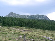
Mont Mézenc

The Mont Mézenc is a summit of the Massif Central, France.
Description
Located at the altitude of 1753 m (5751 feet) - for the South Summit, and 1744 m (5722 feet) for the North Summit - in the department of Haute-Loire, Auvergne-Rhône-Alpes, France, it's the highest point of the department (and of the department of Ardèche). The Mont Mézenc has a volcanic origin.[1][2][3][4][5][6][7][8][9][10][11] It's a dome of phonolite dating 7 million years.
References
- ^ "Le Mézenc - Mézenc et Gerbier, vacances randonnées sur le Chemin de Stevenson (GR70) : Mézenc Loire Sauvage". Mezencloiresauvage.com. Retrieved 2017-01-25.
- ^ "Le Mont Mézenc - Ardèche Guide". ardeche-guide.com. Retrieved 17 January 2017.
- ^ "Mont Mézenc (1753m)". Altituderando.com. Retrieved 2017-01-25.
- ^ Les Amis du Mézenc. "Les Cahiers du Mézenc Index Dernier cahier". Cahiersdumezenc.free.fr. Archived from the original on 2010-05-16. Retrieved 2017-01-25.
- ^ "Archived copy". Archived from the original on 2009-11-18. Retrieved 2017-01-24.
{{cite web}}: CS1 maint: archived copy as title (link) - ^ "Archive copy". Archive.wikiwix.com. Archived from the original on 2008-12-05. Retrieved 2017-01-25.
{{cite web}}: CS1 maint: archived copy as title (link) - ^ "Archive copy" (PDF). Archive.wikiwix.com. Archived from the original (PDF) on 2011-09-06. Retrieved 2017-01-25.
{{cite web}}: CS1 maint: archived copy as title (link) - ^ "Ardčche & Cevennen - Gabriele Kalmbach - Google Livres". Books.google.fr. Retrieved 2017-01-25.
- ^ "Auvergne 2012-2013 (avec cartes, photos + avis des lecteurs) - Dominique Auzias, Jean-Paul Labourdette, Valжrie Kuhn, Marina Valentin - Google Livres". Books.google.fr. 2012-06-14. Retrieved 2017-01-25.
- ^ "Le Mont-Mézenc (1753 m) et le Mont-Meygal (1436 m): un suzerain et son ... - Christian Bertholet, Joan Deville - Google Livres". Books.google.fr. Retrieved 2017-01-25.
- ^ "Un matin sur le mont chauve des Cévennes". Lemonde.fr. 2016-11-15. Retrieved 2017-01-25.
