
Hanhofen
Hanhofen | |
|---|---|
 Church of Saint Martin | |
 Coat of arms | |
Location of Hanhofen within Rhein-Pfalz-Kreis district 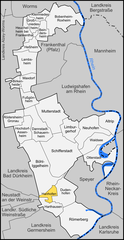 | |
 Hanhofen  Hanhofen | |
| Coordinates: 49°18′58″N 8°20′36″E / 49.31611°N 8.34333°E | |
| Country | Germany |
| State | Rhineland-Palatinate |
| District | Rhein-Pfalz-Kreis |
| Municipal assoc. | Römerberg-Dudenhofen |
| Founded | 1156 |
| Government | |
| • Mayor | Friederike Ebli (SPD) |
| Area | |
| • Total | 5.80 km2 (2.24 sq mi) |
| Elevation | 105 m (344 ft) |
| Population (2022-12-31)[1] | |
| • Total | 2,599 |
| • Density | 450/km2 (1,200/sq mi) |
| Time zone | UTC+01:00 (CET) |
| • Summer (DST) | UTC+02:00 (CEST) |
| Postal codes | 67374 |
| Dialling codes | 06344 |
| Vehicle registration | RP |
| Website | www.dudenhofen.de |
Hanhofen is a municipality in the Rhein-Pfalz-Kreis, in Rhineland-Palatinate, Germany.
Sister-city
Literature
Armgart, Dr. Martin; et al. (2006). 850 Jahre Hanhofen 1156-2006. Streifzüge durch die Ortsgeschichte (in German). Ortsgemeinde Hanhofen. ISBN 3-00-017775-2.
References
- ^ "Bevölkerungsstand 2022, Kreise, Gemeinden, Verbandsgemeinden" (PDF) (in German). Statistisches Landesamt Rheinland-Pfalz. 2023.

| International | |
|---|---|
| National | |
This Rhein-Pfalz-Kreis location article is a stub. You can help Wikipedia by expanding it. |