Säynätsalo
Appearance
Säynätsalo | |
|---|---|
Former Municipality | |
| Säynätsalon kunta Säynätsalo kommun | |
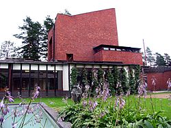
 Säynätsalo Town Hall by architect Alvar Aalto | |
 Location of Säynätsalo in Finland | |
| Coordinates: 62°08.3′N 025°46.9′E / 62.1383°N 25.7817°E | |
| Country | Finland |
| Region | Central Finland |
| Sub-region | Jyväskylä sub-region |
| Founded | 1924 |
| Consolidated | 1993 |
| Area | |
• Total | 9.0 km2 (3.5 sq mi) |
| Population (November 2010) | |
• Total | 3,340 |
| • Density | 370/km2 (960/sq mi) |
| • Metro density | 371/km2 (960/sq mi) |
| Time zone | UTC+2 (EET) |
| • Summer (DST) | UTC+3 (EEST) |
Säynätsalo is a former municipality in Finland and a part of Jyväskylä. As of November 2010 its population was 3,340. Säynätsalo municipality consisted of islands of Säynätsalo and Lehtisaari and also a part of Muuratsalo island. All of the islands are located on the Lake Päijänne. Also a small slice of land on the continent was part of the municipality.
Säynätsalo is famous for Säynätsalo Town Hall.
Gallery
-
A view from Säynätsalo Bridge towards Kinkomaa
-
A house in Säynätsalo
-
Säynätsalo Centre
-
Louhunsalmi Suspension Bridge
-
Teollisuustalo
-
Säynätsalo harbor
-
Plywood Factory
References
- ^ "Area by municipality as of 1 January 2008" (PDF) (in Finnish and Swedish). Land Survey of Finland. Retrieved 23 November 2010.
External links
 Media related to Säynätsalo at Wikimedia Commons


