
Pļavnieki
Pļavnieki | |
|---|---|
Neighborhood of Riga | |
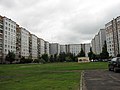
.jpg) Soviet living blocks along Augusta Deglava street. | |
 Location in Riga | |
| Country | |
| City | Riga |
| District | Latgale Suburb, Riga |
| Area | |
| • Total | 2,985 km2 (1,153 sq mi) |
| Population (2018) | |
| • Total | 47 185 |
| Time zone | UTC+2 (EET) |
| • Summer (DST) | UTC+3 (EEST) |
Pļavnieki is a Riga neighbourhood situated to the right of the river Daugava.
Territory of the Pļavnieki for many centuries was used as agricultural land and was added to Riga only in 1974. Project of the new residential neighbourhood for 60 000 people was finished in 1978. Majority of the current residential buildings are built in 1980s. Pļavnieki is one of most densely inhabitated neighbourhoods in Riga.
-
 Andreja Saharova street in Pļavnieki
 -
 Typical inner yard in Pļavnieki
 -
 Post soviet architecture in Pļavnieki.
.jpg)
.jpg)
.jpg)
56°56′24″N 24°12′28″E / 56.94000°N 24.20778°E
This Riga location article is a stub. You can help Wikipedia by expanding it. |