Slab Fork, West Virginia
Slab Fork | |
|---|---|
 Street view, Slab Fork, West Virginia | |
| Coordinates: 37°41′13″N 81°19′53″W / 37.68694°N 81.33139°W | |
| Country | United States |
| State | West Virginia |
| County | Raleigh |
| Population (2000) | |
| • Total | 202 |
| Time zone | UTC-5 (Eastern (EST)) |
| • Summer (DST) | UTC-4 (EDT) |
| ZIP codes | 25920 |
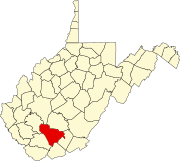
Slab Fork is an unincorporated community in Raleigh County, West Virginia, United States with a population of 202.[1] Slab Fork is located along a stream of the same name and West Virginia Route 54.[2] The ZIP code for Slab Fork is 25920.
Demographics
The community's percentage of married households is lower than the national average, but the percentage of families (households with children) is higher than the national average.[3] The median income in Slab Fork is approximately $33,500, which is 20% lower than the national average. As of the 2000 United States Census, none of the residents had received a college degree. According to the 2000 census, 199 of the community's 202 residents were white, two were of mixed race, and one was an Alaskan native or American Indian.[1]
Notable people
- Bill Withers, Grammy Award-winning singer-songwriter
- Earl Francis, Major League Baseball pitcher
- Doris Payne, noted jewel thief
References
- ^ a b 25920 zip code - Slab Fork
- ^ West Virginia Atlas & Gazetteer. Yarmouth, Me.: DeLorme. 1997. p. 59. ISBN 0-89933-246-3.
- ^ Slab Fork Neighborhood Profile on Yahoo! Real Estate - Demographics, Cost of Living & more!


