Glenorchy, Victoria
| Glenorchy Victoria | |
|---|---|
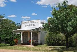
 The former bakery in Glenorchy, now a residence | |
| Coordinates | 36°54′0″S 142°40′0″E / 36.90000°S 142.66667°E |
| Population | 125 (2016 census)[1] |
| Postcode(s) | 3385 |
| Location | |
| LGA(s) | Shire of Northern Grampians |
| State electorate(s) | Ripon |
| Federal division(s) | Wannon |
Glenorchy is a town in the Wimmera district of the Australian state of Victoria. The town in located in the Northern Grampians Shire and on the Wimmera River, 257 kilometres (160 mi) north-west of the state capital, Melbourne. At the 2016 census, Glenorchy had a population of 125.[1]
The town was established around the "Four Posts Inn", opened in 1847 and within two years boasted a store, smithy and post office. The town was surveyed in 1850 by Robert Buchanan who named it after Glen Orchy in Scotland.[2]
In 2010, Glenorchy was subjected to flooding after the Wimmera River broke its banks.[3]
References
Wikimedia Commons has media related to Glenorchy, Victoria.
- ^ a b "2016 Census QuickStats Glenorchy". Australian Bureau of Statistics. Retrieved 15 December 2018.
- ^ "Glenorchy". Film Ballarat Hepburn and Beyond. Film Victoria. Archived from the original on 19 February 2011. Retrieved 7 December 2010.
- ^ "Frustration for Northern Grampians Shire". ABC Western Victoria. Australian Broadcasting Corporation. Retrieved 7 December 2010.


