Prairie, Queensland
| Prairie Queensland | |||||||||||||||
|---|---|---|---|---|---|---|---|---|---|---|---|---|---|---|---|
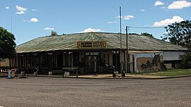
 Prairie Hotel Motel | |||||||||||||||
| Coordinates | 20°52′0″S 144°36′0″E / 20.86667°S 144.60000°E | ||||||||||||||
| Population | 103 (2006 census)[1] | ||||||||||||||
| Postcode(s) | 4821 | ||||||||||||||
| Location |
| ||||||||||||||
| LGA(s) | Shire of Flinders | ||||||||||||||
| State electorate(s) | Traeger | ||||||||||||||
| Federal division(s) | Kennedy | ||||||||||||||
| |||||||||||||||
Prairie is a town and locality in the Shire of Flinders, Queensland, Australia.[2][3]
Geography
The town is in the Shire of Flinders and on the Flinders Highway, 1,548 kilometres (962 mi) north west of the state capital, Brisbane and 338 kilometres (210 mi) west of the regional centre of Townsville.
History
Prairie State School opened in 1894.[4][5] The town is serviced by a hotel/motel (pub) and a cafe/post office.[6]
At the 2006 census, Prairie and the surrounding area had a population of 103.[1]
References
- ^ a b Australian Bureau of Statistics (25 October 2007). "Prairie (Flinders Shire) (State Suburb)". 2006 Census QuickStats. Retrieved 22 April 2012.
- ^ "Prairie – town (entry 27449)". Queensland Place Names. Queensland Government. Retrieved 12 June 2017.
- ^ "Prairie – locality (entry 42487)". Queensland Place Names. Queensland Government. Retrieved 12 June 2017.
- ^ "Flinders Shire". Queensland Places. Centre for the Government of Queensland. Retrieved 22 April 2012.
- ^ "Prairie SS". Retrieved 29 January 2017.
- ^ "Prairie". Shire of Flinders. Retrieved 22 April 2012.
External links
![]() Media related to Prairie, Queensland at Wikimedia Commons
Media related to Prairie, Queensland at Wikimedia Commons

