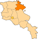
Getahovit
Appearance
40°53′45″N 45°07′53″E / 40.89583°N 45.13139°E
Getahovit
Գետահովիտ | |
|---|---|
| Coordinates: 40°53′45″N 45°07′53″E / 40.89583°N 45.13139°E | |
| Country | Armenia |
| Marz (Province) | Tavush |
| Elevation | 835 m (2,740 ft) |
| Population (2011) | |
• Total | 2,123 |
| Time zone | UTC+4 ( ) |
| • Summer (DST) | UTC+5 ( ) |
Getahovit (Template:Lang-hy; also Tala, Talakand) is a town in the Tavush Province of Armenia.


