Kielcza
Appearance
Kielcza
Keltsch | |
|---|---|
Village | |
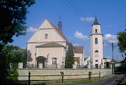
 Saint Bartholomew Church | |
| Coordinates: 50°34′N 18°32′E / 50.567°N 18.533°E | |
| Country | |
| Voivodeship | |
| County | Strzelce |
| Gmina | Zawadzkie |
| Elevation | 220 m (720 ft) |
| Population | 2,000 |
| Website | http://www.kielcza.opole.opoka.org.pl/ |
Kielcza [ˈkʲɛlt͡ʂa] (German: Keltsch) is a village in the administrative district of Gmina Zawadzkie, within Strzelce County, Opole Voivodeship, Upper Silesia in south-western Poland.[1] It lies approximately 7 kilometres (4 mi) south-east of Zawadzkie, 20 km (12 mi) north-east of Strzelce Opolskie, and 44 km (27 mi) east of the regional capital Opole.
Before 1945 the area was part of Germany (see Territorial changes of Poland after World War II).
The village has a population of 2,000.
Main sights
Three objects in Kielcza are considered monuments by National Heritage Board of Poland:
- Saint Bartholomew Church dating back to 1799[2]
- Mass grave of Silesian Uprisings Polish separatist fighters[3]
- Wooden house dating back to 1831[4]
References
- Notes
- ^ "Central Statistical Office (GUS) - TERYT (National Register of Territorial Land Apportionment Journal)" (in Polish). 2008-06-01.
- ^ "Zabytek.pl - Kielcza: kościół parafialny pw. św. Bartłomieja" (in Polish). 2020-05-11.
- ^ "Zabytek.pl - Kielcza: zbiorowa mogiła powstańców śląskich" (in Polish). 2020-05-11.
- ^ "Zabytek.pl - Kielcza: dom" (in Polish). 2020-05-11.
50°34′N 18°32′E / 50.567°N 18.533°E


