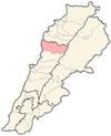
Ras Osta
Appearance
Ras Osta
راس اسطا Ras Usta | |
|---|---|
| Coordinates: 34°6′54″N 35°43′24″E / 34.11500°N 35.72333°E | |
| Country | Lebanon |
| Governorate | Mount Lebanon |
| District | Byblos |
| Area | |
• Total | 429 ha (1,060 acres) |
| Elevation | 900 m (3,000 ft) |
Ras Osta (Template:Lang-ar, also spelled Ras Usta) is a municipality in the Byblos District of Mount Lebanon Governorate, Lebanon. It is 55 kilometers north of Beirut. Ras Osta has an average elevation of 900 meters above sea level and a total land area of 429 hectares. There were two companies with more than five employees operating in the village as of 2008.[1] Its inhabitants are predominantly Shia Muslims.[2]
References
- ^ "Ras Osta". Localiban. Localiban. 18 January 2008. Retrieved 12 February 2016.
- ^ Cammett, Melani; Issar, Sukriti (July 2010). "Bricks and Mortar Clientalism: Sectarianism and the Logics of Welfare Allocation in Lebanon". National Center for Biotechnology Information, U.S. National Library of Medicine. doi:10.1353/wp.0.0056. PMC 4029429.
{{cite web}}: Missing or empty|url=(help)


