
't Haantje, Drenthe
't Haantje | |
|---|---|
Village | |
 Road in 't Haantje | |
 't Haantje  't Haantje | |
| Coordinates: 52°48′53″N 6°49′23″E / 52.81472°N 6.82306°E | |
| Country | Netherlands |
| Province | Drenthe |
| Municipality | Coevorden |
| Government | |
| • Burgemeester | Bert Bouwmeester |
| Population (1 December 2007) | 269 |
't Haantje (the Little Rooster) is a small village in the northeastern Netherlands. It is situated northwest of Emmen and is part of the municipality of Coevorden. It lies along the Oranjekanaal, between Noord-Sleen and Klijndijk.
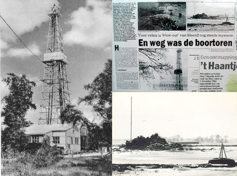
't Haantje was founded in the latter half of the 19th century, when peat labourers spontaneously settled there. On 1 December 1965, the village barely escaped a disaster. A French company working for the N.A.M. was drilling for gas, and started to lose control of the enormous gas pressure. During the afternoon, this resulted in a huge gas eruption. The ground around the hole caved in - swallowing all of the drilling equipment. The gas eruption was eventually stopped by a cement injection from a new drilling hole. A small lake[1] lake surrounded by a forest forms a permanent reminder of this event.
References
- ^ "Wiki Maps". Nsesoftware.nl. Retrieved 2012-09-13.