River Blackwater (River Test)
| Blackwater | |
|---|---|
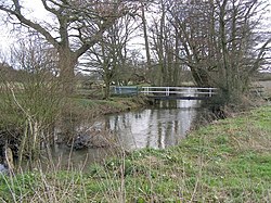
 River Blackwater east of Testwood Lakes | |
| Location | |
| Country | United Kingdom |
| Region | Wiltshire, Hampshire |
| Physical characteristics | |
| Source | |
| • location | Redlynch, Wiltshire |
| • coordinates | 50°59′23″N 1°42′44″W / 50.98972°N 1.71222°W |
| Mouth | Totton |
• location | Hampshire |
• coordinates | 50°55′36″N 1°29′31″W / 50.92667°N 1.49194°W |
| Length | 45.0 km (28.0 mi) |
| Basin size | 67.5 km2 (26.1 sq mi) |
The River Blackwater is a river in the English counties of Hampshire and Wiltshire. It is a tributary of the River Test.
The river rises just to the east of the Wiltshire village of Redlynch, near Salisbury. It then flows east across the county boundary into Hampshire, where it flows north of the village of Wellow and the hamlet of Wigley. The river turns south, passing under the M27 and past Broadlands Lake and the Testwood Lakes reservoirs, before joining the Test between Totton and Redbridge.[1][2] The Environment Agency records the length of the main river as 39.4 kilometres (24.5 mi),[1] with an additional 5.6 km (3.5 mi)[2] for the watercourse from Redlynch to the confluence north of Hamptworth.
See also
This River Blackwater should not be confused with the River Blackwater in north-east Hampshire, which is a tributary of the River Loddon and (indirectly) of the River Thames.
Another similarly named waterway in Hampshire is Black Water, a small stream which flows eastwards across the New Forest, passing under Rhinefield Ornamental Drive, before joining Ober Water and Highland Water just north of Brockenhurst to form the Lymington River.
References
- ^ "Blackwater (Test and Itchen)". Environment Agency - Catchment Data Explorer. Retrieved 23 December 2017.
- ^ "Blackwater". Environment Agency - Catchment Data Explorer. Retrieved 23 December 2017.
- ^ Ordnance Survey (2004). OS Explorer Map OL22 - New Forest. ISBN 0-319-23616-1.
- ^ Ordnance Survey (2004). OS Explorer Map 131 - Romsey, Andover & Test Valley. ISBN 0-319-23600-5.
External links
 Media related to River Blackwater (River Test) at Wikimedia Commons

