Bovensmilde
Bovensmilde | |
|---|---|
Town | |
 | |
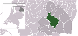
 The town centre (dark green) and the statistical district (light green) of Bovensmilde in the municipality of Midden-Drenthe. | |
| Coordinates: 52°58′33″N 6°28′52″E / 52.97583°N 6.48111°E | |
| Country | Netherlands |
| Province | Drenthe |
| Municipality | Midden-Drenthe |
| Population (2008) | |
| • Total | 3,378 |
| Time zone | UTC+1 (CET) |
| • Summer (DST) | UTC+2 (CEST) |
| Postal code | 9421 |
| Dialing code | 0592 |
Bovensmilde is a town in the Dutch province of Drenthe. It is a part of the municipality of Midden-Drenthe, and lies about 6 km southwest of Assen.
In 2001, the town of Bovensmilde had 2,873 inhabitants. The built-up area of the town was 0.76 km², and contained 1,094 residences.[1] The statistical area "Bovensmilde", which can also include the surrounding countryside, has a population of around 3,960.[2]
On 23 May 1977 Moluccan terrorists occupied an elementary school in Bovensmilde and took 105 children and 5 teachers as hostages. (At the same time other Moluccan terrorists hijacked a nearby train.) After 5 days the children were released. On June 11 the 5 remaining teachers were freed when the school was stormed by a Dutch army tank, and the hostage takers were apprehended.
References
- ^ Statistics Netherlands (CBS), Bevolkingskernen in Nederland 2001. (Statistics are for the continuous built-up area).
- ^ Statistics Netherlands (CBS), Statline: Kerncijfers wijken en buurten 2003-2005 Archived 2006-07-24 at WebCite. As of 1 January 2005.
