Bruntinge
Bruntinge | |
|---|---|
Town | |
 | |
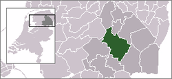
 Bruntinge in the municipality of Midden-Drenthe. | |
| Coordinates: 52°49′2″N 6°34′56″E / 52.81722°N 6.58222°E | |
| Country | Netherlands |
| Province | Drenthe |
| Municipality | Midden-Drenthe |
| Time zone | UTC+1 (CET) |
| • Summer (DST) | UTC+2 (CEST) |
| Postal code | 9435 |
| Dialing code | 0593 |
Bruntinge is a town in the Dutch province of Drenthe. It is a part of the municipality of Midden-Drenthe, and lies about 13 km northeast of Hoogeveen.[1]
References
- ^ ANWB Topografische Atlas Nederland, Topografische Dienst and ANWB, 2005.
