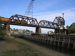
Salmon Bay Bridge
Salmon Bay Bridge | |
|---|---|
 Salmon Bay Bridge seen from the southeast | |
| Coordinates | 47°40′00″N 122°24′08″W / 47.66680°N 122.40213°W |
| Carries | BNSF Railway |
| Crosses | Salmon Bay |
| Other name(s) | Bridge No. 4 |
| Characteristics | |
| Material | Steel |
| History | |
| Opened | 1914 |
| Location | |
 | |
The Salmon Bay Bridge, also known as Bridge No. 4, is a Strauss Heel-trunnion single-leaf bascule bridge spanning across Salmon Bay and connecting Magnolia/Interbay to Ballard in Seattle, Washington. The bridge is located just west of Commodore Park. It carries the main line of the BNSF Railway on its way north to Everett and south to King Street Station and Seattle's Industrial District.
The Salmon Bay Bridge, which is located west of the Hiram M. Chittenden Locks, is the last bridge to span the Lake Washington Ship Canal before it becomes Puget Sound. Built in 1914 by the Great Northern Railway, it has an opening span of 61 meters (200 feet) and has two tracks. Additionally, vessel clearance when lowered is 13.1 meters (43 feet) at mean high tide[1], and up to 15.3 meters (50 feet) at low tide[2].
A project to replace the current single-leaf bascule bridge with a vertical-lift bridge is currently being planned by BNSF Railway.


References
- ^ "Bridge-Navigation". hstrial-troychilds.homestead.com. Retrieved 2018-10-29.
- ^ "Bridge 4". www.gngoat.org. Retrieved 2018-10-29.
External links

- Bridges in Seattle
- Bascule bridges in the United States
- BNSF Railway bridges
- Railroad bridges in Washington (state)
- Bridges completed in 1914
- Great Northern Railway (U.S.) bridges
- 1914 establishments in Washington (state)
- Steel bridges in the United States
- Western United States bridge (structure) stubs
- Washington (state) building and structure stubs
- Washington (state) transportation stubs
