
Hartfield railway station
Hartfield | |
|---|---|
 | |
| General information | |
| Location | Wealden, East Sussex |
| Owned by | Southern Railway Southern Region of British Railways |
| Managed by | London, Brighton and South Coast Railway |
| Platforms | 1 |
| Key dates | |
| 1 October 1866 | Opened |
| 7 May 1962 | Closed to goods traffic |
| 2 January 1967 | Closed to passenger traffic |
Hartfield was a railway station serving Hartfield, England, on the Three Bridges to Tunbridge Wells Central Line which closed in 1967, a casualty of the Beeching Axe.[1]
The station opened on 1 October 1866 and the buildings were designed by Charles Henry Driver.[2]
The station building is now divided between a day nursery and a private house. The route of the railway line is now a cycle path (the Forest Way).[3] A.A. Milne, the creator of Winnie-the-Pooh, lived in Hartfield.
The station appears in a British Transport Film entitled Farmer Moving South, which recounted the moving of the entire farm stock of Robert Ropner, by special train from Skutterskelfe Hall in Yorkshire to Perryhill Farm, Hartfield in December 1950. The entire move took 30 hours and was nine hours late in arriving at East Grinstead on 15 December.[4] The film is available on a BFI DVD.
| Preceding station | Disused railways | Following station | ||
|---|---|---|---|---|
| Forest Row | British Rail Southern Region Three Bridges to Tunbridge Wells Central Line |
Withyham |
Gallery
-
 Remains of the platform from the cycle path
 -
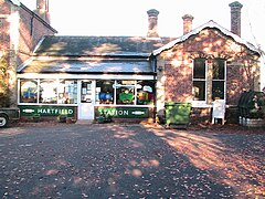 Hartfield station in 2005
 -
 Another view of Hartfield station


See also
References
- ^ Hartfield railway station on Subterranea Britannica
- ^ "Opening of the Tunbridge Wells and East Grinstead Branch of the London, Brighton & South Coast Railway". Sussex Advertiser. British Newspaper Archive. 3 October 1866. Retrieved 8 August 2016 – via British Newspaper Archive.
- ^ "Forest Way" (PDF). East Sussex CC. Retrieved 12 August 2007.
- ^ Gould, David (1983). Three Bridges to Tunbridge Wells. The Oakwood Press. p. 47. ISBN 978-0-85361-299-5.
51°06′22″N 0°06′44″E / 51.1060°N 0.1122°E
This article on a railway station in South East England is a stub. You can help Wikipedia by expanding it. |
- Disused railway stations in East Sussex
- Former London, Brighton and South Coast Railway stations
- Railway stations in Great Britain opened in 1866
- Railway stations in Great Britain closed in 1967
- Beeching closures in England
- 1866 establishments in England
- Charles Henry Driver railway stations
- Wealden
- South East England railway station stubs