Moengotapoe
Moengotapoe | |
|---|---|
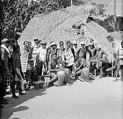
 Moengotapoe (1955) | |
 Map showing the resorts of Marowijne District. Moengotapoe | |
| Country | |
| District | Marowijne District |
| Area | |
| • Total | 455 km2 (176 sq mi) |
| Elevation | 6 m (20 ft) |
| Population (2012)[1] | |
| • Total | 579 |
| • Density | 1.3/km2 (3.3/sq mi) |
| Time zone | UTC-3 (AST) |
Moengotapoe is a resort in Suriname, located in the Marowijne District. Its population at the 2012 census was 579.[1]
The birthplace of Ronnie Brunswijk is the village of Moiwana[2] which is located in the resort of Moengotapoe. Brunswijk, a Maroon, led the Surinamese Liberation Army, known as the Jungle Commando, in a civil war from 1986 to 1990 seeking recognition and improved conditions for Maroons in the country. He also sought to overturn the military rule government.[2] Moiwana was the scene of the 1986 Moiwana massacre where 35 people, mostly women and children were killed by the National Army.[3] The village of Moengotapoe was not spared during the civil war either, because it was the home of Brunswijk at the time.[4] On 22 July 1986, Brunswijk captured the military post near Stolkertsijver and opened fire on the army barracks in Albina. The National Army responded by destroying the temple in Moengotapoe, and capturing all males present. The women and children fled the village.[5]
References
- ^ a b "Resorts of Suriname. 2012 census" (PDF). Spang Staging. Retrieved 14 May 2020.
- ^ a b "Het bloedbad van Moiwana in Suriname". Is Geschiedenis.nl (in Dutch). Retrieved 14 May 2020.
- ^ "Suriname 2003 report". Amnesty International via web.archive.org. Retrieved 14 May 2020.
- ^ "Leger Suriname zoekt gijzelaars". Reformatorisch Dagblad via Digibron (in Dutch). 26 July 1986. Retrieved 17 May 2020.
- ^ "The Kingdom Of The Netherlands In The Caribbean. Suriname 1954 – 2004: Kroniek van een illusie". Rozenberg Quarterly (in Dutch). Retrieved 14 May 2020.

