
Warns, Netherlands
This article needs additional citations for verification. (May 2019) |
Warns | |
|---|---|
Village | |
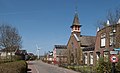
 St John the Baptist Church | |
 Flag  Coat of arms | |
 Location in the former Nijefurd municipality | |
 Warns Location in the Netherlands | |
| Coordinates: 52°52′55″N 5°24′16″E / 52.88194°N 5.40444°E | |
| Country | |
| Province | |
| Municipality | |
| Population (2017) | |
| • Total | 720 |
| Time zone | UTC+1 (CET) |
| • Summer (DST) | UTC+2 (CEST) |
| Postal code | 8721 |
| Dialing code | 0514 |
Warns is a village in the northern Netherlands. It is located in the municipality of Súdwest-Fryslân, Friesland. It had a population of around 720.in January 2017.[1]
History
Before 2011, the village was part of the Nijefurd municipalityand before 1984 it belonged to Hemelumer Oldeferd municipality.
Gallery
-
 Memorial to the battle at Warns
 -
 Village house (De Spylder) in the street
 -
 Reformed church in the street


See also
References
- ^ Kerncijfers wijken en buurten 2017 - CBS Statline
External links
![]() Media related to Warns at Wikimedia Commons
Media related to Warns at Wikimedia Commons
This Friesland location article is a stub. You can help Wikipedia by expanding it. |