St. Leon, Manitoba
49°21′49″N 98°35′22″W / 49.36361°N 98.58944°W
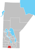
St. Leon in Manitoba
St. Leon (French: Saint-Léon) is an unincorporated community recognized as a local urban district[1] in Manitoba, Canada. It is located in the Municipality of Lorne to the southwest of Winnipeg, near the United States border. The community is best known as the site of the St. Leon Wind Farm project.

See also
References
- ^ "Local Urban Districts Regulation". Government of Manitoba. April 23, 2016. Retrieved April 24, 2016.


