Minami-morimachi Station
Minami-morimachi Station 南森町駅 | |||||
|---|---|---|---|---|---|
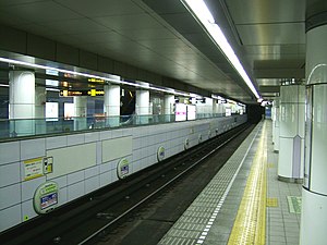
 The Tanimachi Line platforms | |||||
| General information | |||||
| Location | 2 Minamimorimachi, Kita-ku, Osaka-shi, Osaka-fu (大阪市北区南森町二丁目) Japan | ||||
| Operated by | Osaka Metro | ||||
| Line(s) | |||||
| Other information | |||||
| Station code | T21, K13 | ||||
| History | |||||
| Opened | 24 March 1967 | ||||
| |||||
Minami-morimachi Station (南森町駅, Minami-morimachi-eki) is a railway station on the Osaka Metro in Kita-ku, Osaka, Japan.
Lines
Minami-morimachi Station is served by the following two Osaka Municipal Subway lines.
- Tanimachi Line (T21)
- Sakaisuji Line (K13)
Station layout
Tanimachi Line
upper: platform 1
left: for Dainichi
right: for Yaominami
There are an island platform and a side platform with two tracks on the second basement level.
| 1 | ■ Tanimachi Line | for Tennoji and Yaominami |
| 2 | ■ Tanimachi Line | for Higashi-Umeda, Miyakojima and Dainichi |
The station was originally built with an island platform, but overcrowding prompted construction of a second platform (construction was completed on 10 October 1997). As of 2017, the side platform is used for northbound trains, and the northbound side of the island platform is fenced off.
Sakaisuji Line
There are two side platforms with two tracks on the first basement level.
| 1 | ■ Sakaisuji Line | for Sakaisuji-Hommachi, Nippombashi, Dobutsuen-mae and Tengachaya |
| 2 | ■ Sakaisuji Line | for Tenjimbashisuji Rokuchome, Awaji, Kita-Senri and Takatsuki-shi |
Adjacent stations
| « | Service | » | ||
|---|---|---|---|---|
| Tanimachi Line (T21) | ||||
| Higashi-Umeda (T20) | - | Temmabashi (T22) | ||
| Sakaisuji Line K13 | ||||
| Ogimachi K12 | Local | Kitahama K14 | ||
| Ogimachi K12 | Semi-Express | Kitahama K14 | ||
| Extra Limited Express "Hozu": Does not stop at this station | ||||
History
The station opened on 24 March 1967, served by the Tanimachi Line. The Sakaisuji Line platforms opened on 6 December 1969.
Surrounding area
- Osaka-Temmangu Station (on the JR Tōzai Line)
- Osaka Temmangu Shrine
- National Route 1 (Sonezaki-dori)
- Osaka Prefectural Route 14 Osaka Takatsuki Kyoto Route (Tenjimbashisuji)
- Osaka Prefectural Route 102 Ebisu minami-morimachi Route (Tenjimbashisuji)
- Japan Mint
- Temma Tenjin Hanjotei
- Daiwa Minami-morimachi Building
- Tenjimbashisuji Shopping Arcade
- Sumitomo Mitsui Banking Corporation
- The Yomiuri Shimbun Osaka
See also
External links
- Minami-morimachi Station - Sakaisuji Line from Osaka Metro website (in Japanese)
- Minami-morimachi Station - Tanimachi Line from Osaka Metro website (in Japanese)

