Harmelen
Appearance
Harmelen | |
|---|---|
Town | |
 Catholic church in Harmelen, designed by Jan Stuyt | |
 | |
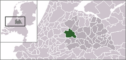
 Harmelen in the municipality of Woerden. | |
| Coordinates: 52°5′22″N 4°57′39″E / 52.08944°N 4.96083°E | |
| Country | Netherlands |
| Province | Utrecht |
| Municipality | Woerden |
| Area | |
• Total | 23.75 km2 (9.17 sq mi) |
| Population (1 January 2010) | |
• Total | 8,374 |
| • Density | 350/km2 (910/sq mi) |
| Time zone | UTC+1 (CET) |
| • Summer (DST) | UTC+2 (CEST) |
Harmelen is a town in the Dutch province of Utrecht. It is a part of the municipality of Woerden, and lies about 6 km east of Woerden.
In 2001, the town of Harmelen had 6557 inhabitants. The built-up area of the town was 1.11 km², and contained 2481 residences.[1]
Harmelen is on the railway line between Utrecht and Woerden; its train station was opened on 21 May 1855 and closed on 15 May 1936.[2] In 1962, two passenger trains collided near Harmelen. The Harmelen train disaster, resulting in 93 fatalities, was the largest train accident in Dutch history.
The village used to be a separate municipality, until it merged with Woerden in 2001. Before the merger the municipality of Harmelen had about 8000 inhabitants.
Notable people born in Harmelen
- Ellen van Dijk, (born 1987) – professional racing cyclist
- Dico Koppers, (born 1992) – soccerplayer by Ajax
- Theo de Rooij, (born 1957) – former racing cyclist and manager of the Rabobank cycling team
- James Cornelius van Miltenburg, (born 1909) – first Archbishop of Karachi
References
- ^ Statistics Netherlands (CBS), Bevolkingskernen in Nederland 2001 [1]. Statistics are for the continuous built-up area.
- ^ Stationsweb.nl
External links
- Template:Kuyper Map of the former municipality in 1868.

