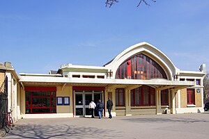
Pont Cardinet station
Pont-Cardinet | |
|---|---|
 | |
| General information | |
| Location | 145, Rue Cardinet 75017 Paris France |
| Coordinates | 48°53′16.08″N 2°18′50.76″E / 48.8878000°N 2.3141000°E |
| Elevation | 36m |
| Owned by | SNCF |
| Operated by | SNCF |
| Platforms | 4 |
| Tracks | 6 (+ numerous passing tracks) |
| Other information | |
| Station code | 8738111 |
| Fare zone | 1 |
| History | |
| Opened | May 2, 1854 |
| Electrified | yes |
| Previous names | Gare des Batignolles (1854-1922) |
| Passengers | |
| 2018 | 7 229 482[1] |
Gare de Pont-Cardinet is a railway station in Paris. It is situated on the Paris–Le Havre railway. It is the first station on the line originating from Gare Saint-Lazare, Paris. The station building is situated above the track level alongside Rue Cardinet. The station is equipped with escalators and Solari destination boards. The main line continues towards Clichy whilst a small line, now closed, branches off towards Pereire-Levallois and links St Lazare to the RER C, this branch was once part of Ligne d'Auteuil and closed in June 1996. Today, there are shuttle buses connecting Pereire-Levallois on RER C. In 2020, the station will be connected to métro line 14 with the construction of the Pont-Cardinet Metro Station.
History
Originally named Gare des Batignolles, the station opened on May 2, 1854 along with on the Auteuil railway.
| Preceding station | SNCF | Following station | ||
|---|---|---|---|---|
toward Template:Transilien stations | Template:Transilien lines | toward Template:Transilien stations |
References
- ^ "Fréquentation en gares". SNCF. Retrieved 9 December 2019.
External links
- Pont Cardinet station at Transilien, the official website of SNCF (in French)
