Põhja-Tallinn
Appearance
Põhja-Tallinn | |
|---|---|
District of Tallinn | |
 Põhja-Tallinn from Pikk Hermann tower. | |
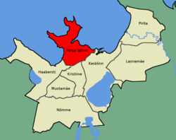
 Location of Põhja-Tallinn in Tallinn. | |
| Coordinates: 59°26′56″N 24°41′53″E / 59.44889°N 24.69806°E | |
| Country | Estonia |
| County | Harju County |
| City | Tallinn |
| Government | |
| • District Elder | Peeter Järvelaid (Centre Party) |
| Area | |
| • Total | 17.3 km2 (6.7 sq mi) |
| Population (01.11.2014[1]) | |
| • Total | 58,926 |
| • Density | 3,400/km2 (8,800/sq mi) |
| Website | northern-tallinn |
Põhja-Tallinn (Estonian for "Northern Tallinn") is one of the 8 administrative districts (Estonian: linnaosa) of Tallinn, the capital of Estonia.
Subdistricts
Põhja-Tallinn is divided into 9 subdistricts (Estonian: asum): Kalamaja, Karjamaa, Kelmiküla, Kopli, Merimetsa, Paljassaare, Pelgulinn, Pelguranna and Sitsi.
Population
| Ethnic group | Percentage |
|---|---|
| Russians | 45.6% |
| Estonians | 45.1% |
| Ukrainians | 3.9% |
| Belarusians | 2.2% |
| Finns | 0.5% |
| Jews | 0.3% |
| Tatars | 0.3% |
| Others | 2.1% |
Põhja-Tallinn has a population of 58,926 (As of 1 November 2014[update]).[1]
| Year | 2004 | 2005 | 2006 | 2007 | 2008 | 2009 | 2010 | 2011 | 2012 | 2013 | 2014 |
|---|---|---|---|---|---|---|---|---|---|---|---|
| Population | 56,044 | 56,997 | 56,994 | 55,691 | 55,626 | 55,478 | 56,005 | 56,346 | 56,443 | 56,914 | 58,385 |
Gallery
-
Former administrative building of Russo-Baltic shipyard in Kopli, now used by the Estonian Maritime Academy.
-
Former Baltic cotton factory building in Sitsi.
-
Dwelling of the workers of Baltic cotton factory.
-
Former Patarei Prison in Kalamaja.
-
Schoolhouse in Pelgulinn.
-
Wooden apartment buildings in Pelgulinn.
-
Stalin-era apartment building in Pelguranna.
-
Typical Khrushchyovkas in Pelguranna.
-
Stroomi Beach
-
Merimetsa park-forest
-
New residential sub-district at Noblessner port. Noblessner
References
- ^ a b "Tallinna elanike arv" (in Estonian). Tallinn City Government. Retrieved 27 November 2014.
- ^ "Tallinn arvudes 2013" (in Estonian). Tallinn. p. 19. Retrieved 10 September 2013.
External links
Wikimedia Commons has media related to Põhja-Tallinn.


