
Voranava
Voranava | |
|---|---|
Town | |
 Flag  Coat of arms | |
 Voranava | |
| Coordinates: 54°09′N 25°19′E / 54.150°N 25.317°E | |
| Country | |
| Elevation | 165 m (541 ft) |
| Population (2007) | 7,000 |
Voranava or Voronovo (Belarusian: Воранава, Russian: Вороново, Template:Lang-pl, Lithuanian: Voranavas) is a town in Belarus, in Grodno Region. It is the administrative center of the Voranava district. It is located about 32 km (20 mi) from Lida and 13 km (8 mi) from the Belarusian-Lithuanian border.
History
Within the Grand Duchy of Lithuania, Voranava was part of Vilnius Voivodeship. In 1795, the town was acquired by the Russian Empire in the course of the Third Partition of Poland.
From 1921 until 1939, Voranava was part of the Second Polish Republic. In September 1939, the town was occupied by the Red Army and, on 14 November 1939, incorporated into the Byelorussian SSR. From 23 June 1941 until 11 July 1944, Voranava was occupied by Nazi Germany and administered as a part of the Generalbezirk Weißruthenien of Reichskommissariat Ostland.
Population
- 1865 — 468 people, (333 Jews, 117 Catholics, 18 Orthodox).
- 1905 — 500
- 1921 — 1232
- 1976 — 3600.
- 1990 — 6800.
- 1996 — 6700.
- 2004 — 6600.
- 2005 — 6559
- 2006 — 6498
- 2007 — 6400.
- 2008 — 6400.
- 2015 — 6200
- 2016 — 6434
In Voronovo district today live more than 32000 people, 83% are Polish.
Sights
-
 Church of the God's Mercy
 -
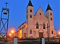 Church of the God's Mercy
 -
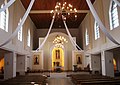 Church of the God's Mercy inner interior
 -
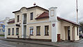
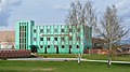
 Building of the Voranava district court
 -
 Pharmacy building
 -
 District house of culture
 -
 Monument to defenders of the motherland World War II
 -
 Monument to defenders of the motherland World War II
 -
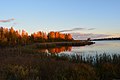 Voranava lake 2015
 -

-
 Palace of Scipio del Campo (19th century)
 -
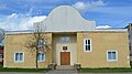 Synagogue 20th century
 -
 Voranava Farm machinery
 -
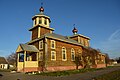 Church of Alyaksandar Neuski


External links
| International | |
|---|---|
| National | |
This Belarus location article is a stub. You can help Wikipedia by expanding it. |