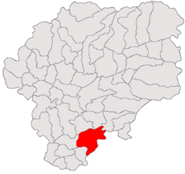
Teaca
Appearance
Teaca | |
|---|---|
 Location in Bistrița-Năsăud County | |
| Coordinates: 46°55′N 24°31′E / 46.917°N 24.517°E | |
| Country | Romania |
| County | Bistrița-Năsăud |
| Area | 140.80 km2 (54.36 sq mi) |
| Population (2021-12-01)[1] | 4,991 |
| • Density | 35/km2 (92/sq mi) |
| Time zone | EET/EEST (UTC+2/+3) |
| Vehicle reg. | BN |
Teaca (German: Tekendorf,[2] Hungarian: Teke) is a commune in Bistrița-Năsăud County, Transylvania, Romania. It is composed of six villages: Archiud, Budurleni, Ocnița, Pinticu, Teaca and Viile Tecii.
| In Romanian | In German | In Hungarian |
|---|---|---|
| Archiud | Arkeden bei Bistriz | Mezőerked |
| Budurleni | Budurló | |
| Ocnița | Salzgruben | Mezőakna |
| Pinticu | Pintak | Szászpéntek |
| Teaca | Tekendorf | Teke |
| Viile Tecii | Großeidau | Kolozsnagyida |
References
- ^ "Populaţia rezidentă după grupa de vârstă, pe județe și municipii, orașe, comune, la 1 decembrie 2021" (XLS). National Institute of Statistics.
- ^ Tekendorf in Nordsiebenbürgen : Ortsmonographie; Ilse Schliessleder-Fronius, 1989


