Atafu

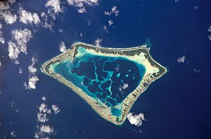
Atafu, formerly known as the Duke of York Group, is a group of 52 coral islets within Tokelau in the south Pacific Ocean, 500 kilometres (310 miles) north of Samoa.[1] Covering 2.5 square kilometres (1.0 square mile), it is the smallest of the three islands that constitute Tokelau, and is composed of an atoll surrounding a central lagoon, which itself covers some 15 km2 (5.8 sq mi). The atoll lies some 800 kilometres (500 miles) south of the equator at 8° 35' South, 172° 30' West.
Population
According to the 2016 census 541 people officially live on Atafu (however just 413 were present at census night).[2] Of those present, 78% belong to the Congregational Church.[3] The main settlement on the atoll is located on Atafu Island at the northwestern corner of the atoll. The Presbyterian church was established on the island in 1858, but today almost all of the residents belong to the Congregational Christian Church.[3] The first village on Atafu was established at the southern end of the islet, and residents built houses along the lagoon shore to receive the cooling trade winds.
The men on Atafu are highly skilled at fishing, and they use many traditional methods that are passed on from fathers to sons. They make very effective lures, fish traps, nets, and seines, and noose fishing is still common.[4] They also make well-crafted canoes, which are important vehicles for their fishing expeditions.
Geography

Atafu lies in the Pacific hurricane belt. In January 1914, a massive storm demolished the church and most of the houses on the islands, and wiped out many of the coconut palms.[5]
The atoll is roughly triangular in shape and encloses a lagoon some five kilometres (3.1 miles) north to south by four kilometres (2.5 miles) east to west at its widest point. It is low-lying, reaching a maximum altitude of only some five metres (16 feet), and is heavily vegetated with coconut palms and other trees, with undergrowth similar to that found on many small central Pacific islands. Lizards, rats, and seabirds are common on Atafu island.[5] The atoll attracts a wide variety of fish in large numbers.
The eastern side of the lagoon is a nearly continuous thin strip of land with one small break halfway along its length. In contrast, the western side is composed of reef and several distinct islands, notably the inverted V shape of Atafu Island in the north, Alofi, which extends into the lagoon from the western reef, and the L-shaped Fenualoa in the southwest. The smaller Tamaseko Island lies in the lagoon close to Alofi.
The reef which connects the islands of the atoll is shallow enough that it is possible to walk between the islands at low tide. This also means that there is no boat passage to the lagoon, although the ocean becomes deep very close to the reef. This allows for good anchorage, but also makes for rough seas close to the reef. The flatness of the atoll and its location within the tropical cyclone belt has led to damage to island properties on occasion.
Islets
- Fogalaki i Lalo
- Fogalaki-Matangi (Fogalaki i Matagi)
- Te Oki
- Te Hepu
- Laualalava
- Te Kapi
- Na Utua
- Motu Atea
- Motu Fakalalo
- Tama Hakea
- Hakea Lahi ki Matagi
- Hakea O Himi
- Malatea
- Kenakena
- Malo o Futa
- Motu o Te Lakia
- Komulo
- Hakea o Apelamo
- Na Hapiti
- Niuefa
- Fenualoa
- Te Puka
- Tamaheko
- Te Alofi
- Tulua a Kovi
- Tagi a Kuli
- Hakea o Himi
- Tulua a Kava
- Motu o te Niu
- Malatea
- Hakea o Hoi
- Hakea o Fata
- Kenakena
- Matu o Tenumi
- Matu o te Lakia
- Motu Fakaka kai
- Malo o Futa
- Malo o Futa
- Motu o te Fala
- Tafega
- Komulo
- Hakela Lahi i Lalo
- Hotoma
- Hakea o Apelamo
- Na Hapiti
- Niuefa
- Fenualoa
- Te Puka
- Tamaheko
- Te Alofi
- Ulugagie
- Atafu Village
History

It is likely that Polynesians visited the island in ancient times, but they may not have settled there. The European discovery of the atoll came on 21 June 1765, by John Byron, of HMS Dolphin. Byron found no-one living on the island at that time,[4] and he named the island "Duke of York's island".[6] Atafu was established by Tonuia and his wife Lagimaina, along with their seven children.[7]
Between 1856 and 1979, the United States claimed that it held sovereignty over the island and the other Tokelauan atolls. In 1979, the U.S. conceded that Tokelau was under New Zealand sovereignty, and a maritime boundary between Tokelau and American Samoa was established by the Treaty of Tokehega.
On 26 August 2007, the attempt by Ralph Tuijn to row from South America to Australia crashlanded on Atafu.[8] On 26 November 2010, three teenage boys from Atafu were rescued after drifting 1,300 km (800 mi) for 50 days in the Pacific.[9][10]
See also
References
- ^ Tokelau Government
- ^ "2016 Tokelau Census atoll profiles" (PDF). tokelau.org.nz.
- ^ a b "2016 Final data tables" Retrieved 13-07-2017
- ^ a b "Atafu". Council for the Ongoing Government for Tokelau. Archived from the original on 15 August 2007. Retrieved 5 April 2008.
- ^ a b Atafu Island on janeresture.com
- ^ *Quanchi, Max (2005). Historical Dictionary of the Discovery and Exploration of the Pacific Islands. The Scarecrow Press. ISBN 0810853957.
- ^ Ethnology of the Tokelau Islands, Gordon MacGregor, 1937
- ^ "Zeeman Ocean Challenge". Archived from the original on 8 February 2012. Retrieved 1 September 2007.
- ^ Field, Michael (27 November 2010). "Boozy teens' midnight trip goes 1300km astray". The Dominion Post. Retrieved 17 September 2011.
- ^ "Joy in Tokelau over rescue of missing teenagers". Radio New Zealand International. 27 November 2010. Retrieved 27 November 2010.

