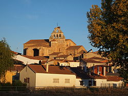
La Hiniesta
Appearance
La Hiniesta | |
|---|---|
 | |
 | |
| Country | |
| Autonomous community | |
| Province | |
| Municipality | La Hiniesta |
| Area | |
| • Total | 33 km2 (13 sq mi) |
| Population (2018)[1] | |
| • Total | 320 |
| • Density | 9.7/km2 (25/sq mi) |
| Time zone | UTC+1 (CET) |
| • Summer (DST) | UTC+2 (CEST) |
La Hiniesta, 7 km from the capital, Zamora, of (Reino de León) currently belongs to the province of the same name in the Comunidad Autónoma de Castilla-León in Spain. Uts population was 364 inhabitants (Census 2004 by INE). Its major attraction is the Iglesia de Santa María, a church that King Sancho IV of Leon ordered built in the honor of the Virgin, who appeared to him in una cacería entre unas hiniestas o retamas, from whence it gets its more frequently-used name, Virgen de la Hiniesta. Among its products más destacados, están los Quesos, de una exquisite purity, of both natural and artisanal manufacture.
41°33′N 5°48′W / 41.550°N 5.800°W
- ^ Municipal Register of Spain 2018. National Statistics Institute.
