
Bowes railway station
Bowes | |
|---|---|
| General information | |
| Location | County Durham |
| Platforms | 2 |
| History | |
| Original company | SD&LUR |
| Pre-grouping | North Eastern Railway |
| Key dates | |
| 8 August 1861 | Opened |
| 22 January 1962 | Closed |
Bowes railway station was situated on the South Durham & Lancashire Union Railway between Barnard Castle and Kirkby Stephen East.
History
The line was opened on 26 March 1861 when a mineral train was run, the line opened to passengers on 8 August 1861 following an opening ceremony the day before.[1][2]
The station served the village of Bowes. The station was host to a camping coach in 1933 and from 1937 to 1939 and possibly also in 1934.[3]
The station was closed by British Railways North Eastern Region on 22 January 1962.[4]
The site today
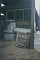
The station buildings are now (2008) in an extreme state of dereliction. A large farm shed covers a portion of the platforms and yard.
The signal box, which for many years after closure was hidden away inside the farm shed, was dismantled by the Eden Valley Railway on 10 and 11 May 1997,[5] and is in storage, awaiting reconstruction at some future point along their line.
The trackbed westwards of the station (towards Stainmore Summit) is covered by the re-aligned A66 road.
Images
-
 Bowes signal box in 1996.
 -
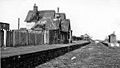 The station in 1965


| Preceding station | Disused railways | Following station | ||
|---|---|---|---|---|
| Barras | South Durham & Lancashire Union Railway | Lartington |
References
- ^ Quick 2019, p. 85.
- ^ "Stockton and Darlington Railway Company. Opening of the South Durham Line, between Barnardcastle and Tebay". Durham Chronicle. 9 August 1861. p. 4. Retrieved 1 June 2020. – via britishnewspaperarchive.co.uk (subscription required)
- ^ McRae 1997, p. 10.
- ^ Quick 2019, p. 63.
- ^ "Bowes Signal Box". 'Online' - The Official Journal of the Eden Valley Railway Society (9 ed.). Summer 1997.
Bibliography
- McRae, Andrew (1997). British Railway Camping Coach Holidays: The 1930s & British Railways (London Midland Region). Vol. Scenes from the Past: 30 (Part One). Foxline. ISBN 1-870119-48-7.
- Quick, Michael (2022) [2001]. Railway passenger stations in Great Britain: a chronology (PDF). version 5.04. Railway & Canal Historical Society. Archived from the original (PDF) on 25 November 2022.
Further reading
- British Railways Pre-Grouping Atlas And Gazetteer. Ian Allan Publishing. 1997 [1958]. ISBN 0-7110-0320-3.
- Butt, R.V.J. (1995). The Directory Of Railway Stations. Patrick Stephens Limited. ISBN 1-85260-508-1.
- Walton, Peter (1992). The Stainmore & Eden Valley Railways. Oxford Publishing Co. ISBN 0-86093-306-7.
External links
- Gallery of photos of Bowes station in its current state
- More photos of Bowes station, past & present
- Photos of Bowes station in 1973
54°31′11″N 2°00′27″W / 54.5197°N 2.0076°W
This article about a County Durham building or structure is a stub. You can help Wikipedia by expanding it. |
This article on a railway station in North East England is a stub. You can help Wikipedia by expanding it. |
- South Durham and Lancashire Union Railway
- Disused railway stations in County Durham
- Former North Eastern Railway (UK) stations
- Railway stations in Great Britain opened in 1861
- Railway stations in Great Britain closed in 1962
- Ruins in County Durham
- 1861 establishments in England
- County Durham building and structure stubs
- North East England railway station stubs