Wanica District
Wanica | |
|---|---|
 | |
 Map of Suriname showing Wanica district | |
| Coordinates: 5°48′N 55°16′W / 5.800°N 55.267°W | |
| Country | Suriname |
| Capital | Lelydorp |
| Area | |
| • Total | 443 km2 (171 sq mi) |
| Population (2012 census)[1] | |
| • Total | 118,222 |
| • Density | 270/km2 (690/sq mi) |
| Time zone | UTC-3 (ART) |
Wanica is a district of Suriname located in the north of the country. Wanica's capital city is Lelydorp, the second largest city in Suriname. Wanica has a population of 118,222 and an area of 443 km². Following neighbouring Paramaribo, Wanica is the second most populated and urbanised district of Suriname. Two-thirds of the country's population live in these two districts.[1]
History
The district was created in 1983 out of parts of the former Suriname District. The district was named Wanica after Pad van Wanica, the main road, Wanica Creek (present in the district), and the fact that the name had already been used on old map.[2]
The discovery of gold in Brokopondo and Sipaliwini lead to the construction of the Lawa Railway and growth of the villages next to the railway line,[3] and especially Kofi Djompo.[4] The railway line was decommissioned in 1986.[5]
The district's capital, originally called Kofi Djompo, was renamed in 1905 for Dutch architect Cornelis Lely, who was responsible for many large construction projects in the Netherlands and was also governor of Suriname.[4] Javanese immigation and the closeness to Paramaribo, have resulted in a partially suburban, and still partially agricultural distruct.[3] The beginning of the 21st century have seen many building projects in the district.[6]
Rice used to be the main crops grown in Wanica, but the late 20th century saw a shift towards animal husbandry. Fruit and vegetables are of lesser significance.[6] Trade and businesses have increased, and are mainly located around Lelydorp. Lelydorp needs a clear city structure and has many agricultural areas close to the centre and neighbourhoods.[6]
Resorts

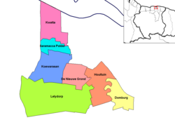
Wanica is divided into 7 resorts (ressorten):
Villages
References
- ^ a b "Resorts in Suriname Census 2012" (PDF). Retrieved 27 May 2020.
- ^ "Distrikt Wanica 1". Suriname.nu (in Dutch). Retrieved 28 May 2020.
- ^ a b "Distrikt Para 2". Anda Suriname (in Dutch). Retrieved 28 May 2020.
- ^ a b "Wanica". Suriname View (in Dutch). Retrieved 28 May 2020.
- ^ Armand Snijders: De flop van Lely. Parbode, Surinames Magazine, 1 April 2008.
- ^ a b c "Structuur analyse" (PDF). Planning Office Suriname (in Dutch). Retrieved 28 May 2020.

