
Mendizorrotza Stadium
 Mendizorrotza football stadium seem from the box. | |
 | |
| Location | Vitoria-Gasteiz, Spain |
|---|---|
| Coordinates | 42°50′13.60″N 2°41′16.96″W / 42.8371111°N 2.6880444°W |
| Owner | Ayuntamiento de Vitoria-Gasteiz |
| Operator | Deportivo Alavés |
| Capacity | 19,840[1] |
| Field size | 105 x 68 m |
| Surface | Grass |
| Construction | |
| Opened | 27 April 1924 |
| Expanded | 1999 |
| Tenants | |
| Deportivo Alavés | |
Mendizorrotza or Mendizorroza is a football stadium in Vitoria-Gasteiz, Spain. The stadium is the home ground of Deportivo Alavés.
History
Opened on 27 April 1924, it is currently the third oldest football stadium in the Spanish Professional Football, behind El Molinón and Mestalla.[2]
During its history, the stadium had several renovations. The most important one was the expansion made in 1999, making new stands in the corners for increasing the capacity of the stadium to the current 19,840 seats.
In December 2016, the club president Josean Querejeta announced a plan of modernisation and expansion of the stadium,[3] possibly bringing its capacity to 28,000.[4]
Gallery
-
 Exterior of the stadium
 -
 The stadium in 2017
 -
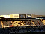
 Interior of the stadium
 -
 The old scoreboard, used until 2015
 -
 Mendizorrotza


References
Wikimedia Commons has media related to Mendizorrotza stadium.
- ^ Mendizorrotza Stadium
- ^ "Cinco cosas que quizá no sabías de Mendizorroza" (in Spanish). LaLiga.es. 1 September 2015. Retrieved 30 May 2016.
- ^ "El nuevo Mendizorrotza, un estadio para Vitoria y Álava" [The new Mendizorrotza, a stadium for Vitoria and Álava] (in Spanish). Deportivo Alavés. 18 December 2016. Retrieved 17 March 2017.
- ^ "Mendizorroza se ampliará hasta los 28.000 espectadores" [Mendizorroza will be expanded to 28,000 spectators] (in Spanish). Diario AS. 25 June 2018. Retrieved 3 March 2019.
External links
- Estadios de España: Vitoria – Estadio Mendizorroza (in English)