
Mount Sibayak
| Mount Sibayak | |
|---|---|
| Gunung Sibayak (Indonesian) Deleng Sibayak (Karo) | |
.jpeg) Sibayak seen from the Southeast | |
| Highest point | |
| Elevation | 2,212 m (7,257 ft) |
| Listing | Ribu |
| Coordinates | 3°14′21″N 98°30′20″E / 3.23917°N 98.50556°E |
| Geography | |
| Geology | |
| Mountain type | Stratovolcano |
| Last eruption | 1881 |

Mt. Sibayak (Indonesian: Gunung Sibayak) is a stratovolcano overlooking the town of Berastagi in northern Sumatra, Indonesia. Although its last eruption was more than a century ago, geothermal activity in the form of steam vents and hot springs remains high on and around the volcano. The vents produce crystalline sulfur, which was mined on a small scale in the past. Seepage of sulfurous gases has also caused acidic discolouration of the small crater lake.
Sibayak is a term from the Karo Batak language referring to a founding community. It is relatively easy to climb and has been a tourist attraction since colonial times.
-
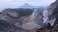 Crater of Gunung Sibayak. Mount Sinabung in the back.
 -
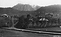 Mount Sibayak in 1920s
 -
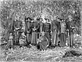 The "Sibajak raja berampat", the so-called four princes with their wives, Karolanden, North Sumatra (1914-1919)


See also
References
External links
![]() Media related to Sibayak at Wikimedia Commons
Media related to Sibayak at Wikimedia Commons
This North Sumatra location article is a stub. You can help Wikipedia by expanding it. |