Carson Pass
| Carson Pass Kit Carson Pass | |
|---|---|
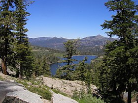
 The Carson Pass (foreground) overlooks Red Lake to the east. | |
| Elevation | 8,574 ft (2,613 m) |
| Traversed by | |
| Location | Sierra Crest, Eldorado National Forest, Alpine County, California, United States |
| Range | Sierra Nevada |
| Coordinates | 38°41′38″N 119°59′15″W / 38.69389°N 119.98750°W |
| Official name | Kit Carson Marker |
| Reference no. | 315 |
Carson Pass is a mountain pass on the crest of the central Sierra Nevada, in the Eldorado National Forest and Alpine County, eastern California.
The pass is traversed by California State Route 88. It lies on the Great Basin Divide, with the West Fork Carson River on the east and the South Fork American River on the west.
The historic pass was a point on the Carson Trail during the California Gold Rush and was used for American Civil War shipping to California until the completion of the First Transcontinental Railroad. The Pacific Crest Trail traverses the Carson Pass summit, which has California Historical Landmark #315 at CA 88 postmile 6.09 where Kit Carson carved his name into a tree.[1]
History
The 1844 Frémont Expedition turned south from northern Nevada. When encamped at Nevada's Carson Valley on January 31, 1844, guide Kit Carson suggested the expedition detour west during the winter conditions to Sutter's Fort in California for supplies. Local Washoe Indians told them of a route through the mountains, but warned them not to proceed through the snow. Frémont duly ignored the advice and directed the group westward. The Washoe were right in that they were not able to find food or game, and they ended up resorting to eating dogs, horses, and mules just to survive. On February 14, Frémont and his cartographer Charles Preuss made it up Red Lake Peak and became the first recorded white men to see Lake Tahoe in the distance. On February 21, the expedition made it through the now-named Carson pass west of Red Lake and arrived at Sutter's Fort on March 6 with no fatalities.[2]
In the summer of 1848, Mormons leaving California for Utah built what would become known as the Carson Trail across the Sierra from Sly Park, California to the Carson Valley via Carson Pass. The Carson Trail became one of the primary routes across the Sierra used by overland immigrants to California in the Gold Rush era. Brigham Young evacuated Mormon settlers around Carson Pass in July 1857, shortly after the breakout of the Utah War.
Maiden's Grave
| Maiden's Grave | |
|---|---|
| Location | State Highway 88, Kirkwood, California |
| Coordinates | 38°37′54″N 120°10′16″W / 38.6318°N 120.171233°W |
| Reference no. | 28 |
In 1850, the young Rachel Melton was buried west of Carson's Pass. Her family was traveling from Iowa when she became ill. The family camped out with a goal to improve Melton's health, but she died. The site is a California Historical Landmark.[3]
References
- ^ "Kit Carson Marker". Office of Historic Preservation, California State Parks. Retrieved 2012-03-30.
The original inscription was cut from the tree in 1888 and is now in Sutter's Fort
- ^ Belli, Anthony M (2004). "Kirkwood History – The Opening of the Kit Carson Pass". Internet Archive (originally Kirkwood Mountain Resort). Archived from the original on 2005-12-15. Retrieved 2010-08-05.
Fremont and Jacob Dodson leave Long Camp on the 16th as an advance scouting party to determine their route over the pass then along the descent of the western slope. On the night of the 17th the two men return to Long Camp and are quite surprised to be greeted by Fitzpatrick and his party from Grover's. Fremont noted… "Here we had the pleasure to find all the remaining animals, 57 in number, safely arrived at the grassy hill near the camp." Two days later the entire second expedition had reached Long Camp. On February 21st the expedition passed over the summit of today's Carson Pass at a location just south of present day Highway 88. They began their descent and two days later Fremont wrote from their camp at present day Strawberry… "Here among the pines, the hill side produces but little grass---barley sufficient to keep life in the animals. We had the pleasure to be rained upon this afternoon; and grass was now are greatest solicitude. Many of the men looked badly, and some this evening were giving out." Although they still had some distance to cover the descent was much easier, the worst was behind them. On March 6, 1844 they reached Sutter's Fort without losing a single man.
: 2 (italic text from expedition reports) - ^ "Maiden's Grave". Office of Historic Preservation, California State Parks. Retrieved 6 October 2012.
External links
- "Memorial to Pioneer Odd Fellows". Office of Historic Preservation, California State Parks. Retrieved 2012-03-30.
