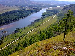
Little Yenisey
| Little Yenisey Small Yenisey | |
|---|---|
 Kaa-Khem | |
| Native name | Малый Енисей Template:Lang-tyv Error {{native name checker}}: <br /> lists not allowed (help) |
| Location | |
| Country | Mongolia, Russia |
| State | Khövsgöl, Tuva |
| Physical characteristics | |
| Source | |
| • location | Khoridol Saridag mountains |
| Mouth | Yenisey |
• location | Kyzyl, Tuva |
• coordinates | 51°30′N 98°2′E / 51.500°N 98.033°E |
| Length | 563 km (350 mi) |
| Basin features | |
| Progression | Yenisey→ Kara Sea |
| Tributaries | |
| • left | Busiyn-Gol, Balyktyg-Khem |
| • right | Sharga, Tengis, Belin |
The Little Yenisey (Russian: Малый Енисей Maly Yenisey) a river in northern Mongolia and in Tuva, Russia.[1] At its confluence with the Great Yenisey in Kyzyl (Tuva), the Yenisey is formed. It is 563 kilometres (350 mi) long, and has a drainage basin of 58,700 square kilometres (22,700 sq mi).[2] It rises in the Darkhad Valley in northwestern Khövsgöl aimag, Mongolia under the name Shishged Gol (Mongolian: Шишгэд гол; Russian: Шишхид-Гол). Within Tuva it is called Kyzyl-Khem (Template:Lang-tyv - red river) and then Kaa-Khem (Template:Lang-tyv - little river) or Maly Yenisey.[3]
In the Darkhad Valley, it receives its tributaries Sharga and Tengis. It flows westward through the Ulaan Taiga Mountain range to Russia. There it is joined by the Busiyn-Gol, the Belin and the Balyktyg-Khem. Of its 563 km length, 298 are in Mongolia. A bridge has been erected near Renchinlkhümbe sum center.

References
- ^ Yenisey River at Britannica
- ^ "Река МАЛЫЙ ЕНИСЕЙ in the State Water Register of Russia". textual.ru (in Russian).
- ^ Малый Енисей, Great Soviet Encyclopedia
