
Paide Parish
Paide Parish
Paide vald | |
|---|---|
 Flag  Coat of arms | |
 Paide Parish within Järva County. | |
| Country | |
| County | |
| Administrative centre | Paide |
| Area | |
| • Total | 300 km2 (100 sq mi) |
| Population (2004) | |
| • Total | 1,935 |
| • Density | 6.5/km2 (17/sq mi) |
| Website | www.paidevald.ee |
Paide Parish (Estonian: Paide vald) was a rural municipality of Estonia, in Järva County. It had a population of 1935 (as of 2004) and an area of 300 km².
Nurmsi Airfield (ICAO: EENI) is located in the parish. During the Cold War, it hosted a front-line fighter air base "Koigi".
Villages
Anna - Eivere - Kirila - Korba - Kriilevälja - Mäeküla - Mäo - Mustla - Mustla-Nõmme - Mündi - Nurme - Nurmsi - Ojaküla - Otiku - Pikaküla - Prääma - Puiatu - Purdi - Sargvere - Seinapalu - Sillaotsa - Sõmeru - Suurpalu - Tarbja - Valgma - Veskiaru - Viraksaare - Võõbu.
-
 Anna
Anna -
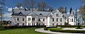 Eivere manor
 -
 Kükita
 -
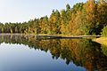 Matsimäe Pühajärv
 -
 Mäo
Mäo -
 Purdi
Purdi -
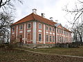 Sargvere
 -
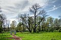 Sargvere manor park
 -
 Viraksaare


58°53′N 25°34′E / 58.883°N 25.567°E
| Urban municipality | ||
|---|---|---|
| Rural municipalities | ||
| Former municipalities | ||
This Järva County location article is a stub. You can help Wikipedia by expanding it. |