Mount Izla
This article includes a list of general references, but it lacks sufficient corresponding inline citations. (November 2010) |

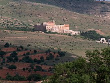
Mount Izla (Template:Lang-syr Ṭūr Īzlā' )[1], also Mountain of Nisibis or briefly in the 9th century Mount Kashyari, is a low mountain or ridge near Nisibis in what once was Sassanid Persia, but is now southeastern Turkey, along the border with Syria. The ridge is the location of dozens of ancient monasteries which were built in the early centuries of Christianity. In modern times, all of the monasteries are in ruins except for that of Mor Melke reconsecrated in the 1930s, Mor Yakub Monastery, founded in Dibek in 2012–2013, and the Monastery of Mor Augin which was refounded in 2008 after being abandoned in the 70's.
Though called a mountain, it is actually a 77-kilometre-long (48 mi) ridge running from east to west, with a plateau on the northern (Turkey) side, and a plain on the southern (Syria) side. One end of the ridge is Dara, a Roman fortification. On the other is Serwan (Sisaranon), the location of the Castle of Tur Abdin, which was built by Constantius II in the 4th century.
Early monasteries, believed to have been founded in the 4th century, are Mar Awgin, Mar Malke, and Mar Samuel. The next was the most famous, Mar Abraham of Kashkar, also known as the Great Monastery, which was founded in the latter part of the 6th century. Later monasteries included that of Rabban Sapra, Mar Yaret, Mar Khudahwi, Za'faran (Saffron), Mar Yohannan the Arab, and Mar Ya'qob. At its peak, there were approximately 40,000 monks on Mt. Izla.
Notable residents
References
- ^ Thomas A. Carlson et al., “Izla — ܛܘܪܐ ܕܐܝܙܠܐ ” in The Syriac Gazetteer last modified January 14, 2014, http://syriaca.org/place/100.
- Wigram, W. A. (2004). An introduction to the history of the Assyrian Church, or, The Church of the Sassanid Persian Empire, 100–640 A.D. Gorgias Press. ISBN 1-59333-103-7.
- Wilmshurst, David (2000). The ecclesiastical organisation of the Church of the East. Peeters Publishers. ISBN 978-90-429-0876-5.
External links
- "Gertrude Bell climbs Mt. Isla" (video). August 7, 2007. Retrieved January 30, 2010.
37°20′00″N 41°10′00″E / 37.33333°N 41.16667°E

