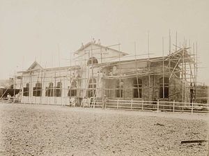
Padalarang railway station
This article includes a list of general references, but it lacks sufficient corresponding inline citations. (November 2011) |
 The Padalarang railway station under construction (1890-1910) | |||||
| General information | |||||
| Location | Padalarang, West Bandung Regency West Java Indonesia | ||||
| Coordinates | 6°50′34.89″S 107°29′50.38″E / 6.8430250°S 107.4973278°E | ||||
| Elevation | +695 m (2,280 ft) | ||||
| Owned by | Kereta Api Indonesia | ||||
| Operated by | Kereta Api Indonesia | ||||
| Line(s) | |||||
| Platforms | 1 side platform 2 island platforms | ||||
| Tracks | 5 | ||||
| Construction | |||||
| Structure type | Ground | ||||
| Parking | Available | ||||
| Accessible | Available | ||||
| Other information | |||||
| Station code | PDL | ||||
| History | |||||
| Opened | 17 May 1884[1] | ||||
| |||||
Padalarang Station is a railway station in West Bandung Regency, West Java.
The station is located near the Cihaliwung area and Cihaliwung traditional market, on the heart of the capital city of Western Bandung Regency, the Padalarang town.
The station located on the western side of Bandung Cities, it is the point where 2 railways route (Cikampek–Padalarang and Manggarai–Padalarang) merged.
Services
The following is a list of train services at the Padalarang Station
Passenger services
- Local economy
- Bandung Raya Local, Destination of Cicalengka
- Cibatu Local, Destination of Cibatu and Purwakarta
Bandung Urban Railway
To ease traffic congestion at the Greater Bandung roads, the Central government will make Bandung Urban Railway which use electric trains with double tracks line between Padalarang-Cicalengka through Bandung. In November 2011, mapping of Padalarang-Bandung route and feasibility study of Bandung-Cicalengka route have been done by local government.[2]
References
- ^ Staatsspoorwegen (1921–1932). Verslag der Staatsspoor-en-Tramwegen in Nederlandsch-Indië 1921-1932. Batavia: Burgerlijke Openbare Werken.
{{cite book}}: CS1 maint: date format (link) - ^ "Padalarang-Bandung-Cicalengka Bakal Dilayani Kereta". November 24, 2011.
External links
- (in Indonesian) PT KAI - the Indonesian rail company
- (in Indonesian) Forum Semboyan35 - Indonesian Rail fans Forum
- (in Indonesian) Padalarang Train Station
6°50′34.89″S 107°29′50.38″E / 6.8430250°S 107.4973278°E
| Preceding station | Kereta Api Indonesia | Following station | ||
|---|---|---|---|---|
| Cilame towards Cikampek |
Cikampek–Padalarang | Terminus | ||
| Tagogapu towards Manggarai |
Manggarai–Padalarang | |||
| Terminus | Padalarang–Kasugihan | Gadobangkong towards Kasugihan |

