
South Wellesley Islands
| South Wellesley Islands Queensland | |
|---|---|
 South Wellesley Islands | |
| Coordinates | 17°00′13″S 139°21′48″E / 17.0037°S 139.3634°E |
| Population | 0 (2016 census)[1] |
| • Density | 0.000/km2 (0.000/sq mi) |
| Postcode(s) | 4871 |
| Area | 144.2 km2 (55.7 sq mi) |
| Time zone | AEST (UTC+10:00) |
| LGA(s) | Shire of Mornington |
| State electorate(s) | Traeger |
| Federal division(s) | Kennedy |

South Wellesley Islands are an island group and locality in the Gulf of Carpentaria within the Shire of Mornington, Queensland, Australia.[2] In the 2016 census, South Wellesley Islands had a population of 0 people.[1]
Geography
The islands are (west to east):
- Allen Island
- Horseshoe Island
- Albinia Island
- Bentinck Island, where a massacre of indigenous inhabitants, including women and children, occurred in 1918 by colonist 'McKenzie'. [3][4]
- Fowler Island
- Sweers Island
-
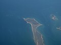
 Southern part of Bentinck Island and Albinia Island
 -
 Bentinck Island with the Australian continent in the background
 -
 the small Fowler Island is located between Seers Island and Bentinck Island
 -
 Location of Bentinck Island
 -
 Southern part of Sweers Island


History
Kayardild (also known as Kaiadilt and Gayadilta) is a language of the Gulf of Carpentaria. The Kayardild language region includes the landscape within the local government boundaries of the Mornington Shire Council.[5]
References
Wikimedia Commons has media related to South Wellesley Islands.
- ^ a b Australian Bureau of Statistics (27 June 2017). "South Wellesley Islands (SSC)". 2016 Census QuickStats. Retrieved 20 October 2018.
- ^ "South Wellesley Islands – locality in Shire of Mornington (entry 42537)". Queensland Place Names. Queensland Government. Retrieved 13 November 2019.
- ^ Bruce Elder (1998). Blood on the Wattle: Massacres and maltreatment of Aboriginal Australians since 1788. Page 203 - 206: New Holland Publishers. ISBN 1-86436-410-6.
{{cite book}}: CS1 maint: location (link) - ^ Kelly, Roma; Evans, Nicholas (1985). "The McKenzie massacre on Bentinck Island" (PDF). Aboriginal History. 9 (1). Archived (PDF) from the original on 11 February 2020. Retrieved 13 April 2020.
- ^
 This Wikipedia article incorporates CC-BY-4.0 licensed text from: "Indigenous languages map of Queensland". State Library of Queensland. State Library of Queensland. Retrieved 5 February 2020.
This Queensland location article is a stub. You can help Wikipedia by expanding it. |