Saint David Parish, Dominica
Appearance
Saint David | |
|---|---|
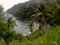
 Carib Territory coast | |
 | |
| Country | Dominica |
| Capital | Castle Bruce |
| Area | |
• Total | 131.5 km2 (50.8 sq mi) |
| Population (2011) | |
• Total | 6,043 |
| • Density | 46/km2 (120/sq mi) |
| Time zone | UTC-4 |
| ISO 3166-2 | DM-03 |
Saint David is one of Dominica's ten administrative parishes, located on the eastern side of the island.[1] It is bordered by St. Andrew to the north; St. Joseph, St. Paul and St. George to the west; and St. Patrick to the south. It has an area of 131.6 km² (50.8 mi²),[2] and has a population of 6,789.[3]
Settlements
Its largest settlement is Castle Bruce, with a population of 1,653.[3] It includes the Indigenous community of the *Carib Territory. (Kalinago Territory) which has a population of about 3000 spread across 7 hamlets. Other villages include:
- Grand Fond
- Rosalie
- Good Hope
- Petit Soufrière
- Riviere Cyrique
- Morne Jaune
- San Sauveur
- Carib Territory
- Atkinson
- Antrizle
Areas of interest
The northern area of the parish is also home to the island's Carib Territory, in and around which 3,000 pure, indigenous Caribs live.
References
- ^ "The World Factbook". CIA. Retrieved 2020-03-27.
- ^ Figures provided by the Lands and Surveys Division of the Ministry of Agriculture, Cork Street, Roseau, Dominica.
- ^ a b Commonwealth of Dominica, Population and Housing Census – 2001. Roseau, Dominica: Central Statistical Office, Ministry of Finance and Planning, Kennedy Avenue, 2001.
