Huachuca City, Arizona
Huachuca City | |
|---|---|
| Huachuca City, Arizona | |
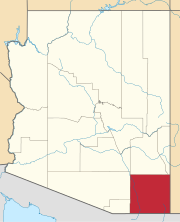
 Location of Huachuca City in Cochise County, Arizona. | |
| Coordinates: 31°38′10″N 110°20′11″W / 31.63611°N 110.33639°W | |
| Country | United States |
| State | Arizona |
| County | Cochise |
| Incorporated | 1958 |
| Government | |
| • Mayor | Johann Wallace |
| Area | |
• Total | 2.83 sq mi (7.32 km2) |
| • Land | 2.83 sq mi (7.32 km2) |
| • Water | 0.00 sq mi (0.00 km2) |
| Elevation | 4,400 ft (1,341 m) |
| Population | |
• Total | 1,853 |
• Estimate (2019)[3] | 1,736 |
| • Density | 614.30/sq mi (237.15/km2) |
| Time zone | UTC-7 (MST (no DST)) |
| ZIP code | 85616 |
| Area code | 520 |
| FIPS code | 04-34120 |
| GNIS feature ID | 6076 |
| Website | Town of Huachuca City |
Huachuca City is a town in Cochise County, Arizona, United States. As of the 2010 census, the population was 1,853.[2]
Fort Huachuca, a U.S. Army base, is located just south of the municipality.
History
Huachuca City started out as a stop along the Southern Pacific Railroad. The rail stretched between Tombstone and Patagonia and is no longer in operation today. With the re-opening of Fort Huachuca in 1954, the area began to grow and while it went through many name changes - Campstone Station, Sunset City, and Huachuca Vista - it finally settled on the name Huachuca City and incorporated in 1958.
Today, Huachuca City is a small town located at the north exit of Fort Huachuca, the major employment for the town. With retirees moving in and tourism a major business because of the proximity to Tombstone and Kartchner Caverns State Park, Huachuca City is a growing area.
Geography
Huachuca City is located in southwestern Cochise County. The city of Sierra Vista and Fort Huachuca lie along the town's southern border.
According to the United States Census Bureau, the town has a total area of 2.8 square miles (7.3 km2), all of it land.
Climate
According to the Köppen Climate Classification system, Huachuca City has a semi-arid climate, abbreviated "BSk" on climate maps.[4]
Transportation
Via Arizona State Route 90 it is 23 miles (37 km) north to Interstate 10 near the city of Benson.
Huachuca City Transit, operated by the city, runs between Huachuca City and Sierra Vista.[5]
Demographics
| Census | Pop. | Note | %± |
|---|---|---|---|
| 1960 | 1,330 | — | |
| 1970 | 1,241 | −6.7% | |
| 1980 | 1,661 | 33.8% | |
| 1990 | 1,782 | 7.3% | |
| 2000 | 1,751 | −1.7% | |
| 2010 | 1,853 | 5.8% | |
| 2019 (est.) | 1,736 | [3] | −6.3% |
| U.S. Decennial Census[6] | |||
As of the census[7] of 2000, there were 1,751 people, 713 households, and 432 families residing in the town. The population density was 625.6 people per square mile (241.5/km²). There were 844 housing units at an average density of 301.5 per square mile (116.4/km²). The racial makeup of the town was 75.39% White, 6.80% Black or African American, 2.68% Native American, 1.48% Asian, 0.23% Pacific Islander, 8.17% from other races, and 5.25% from two or more races. 16.28% of the population were Hispanic or Latino of any race.
There were 713 households out of which 31.3% had children under the age of 18 living with them, 44.3% were married couples living together, 12.3% had a female householder with no husband present, and 39.3% were non-families. 32.8% of all households were made up of individuals and 11.5% had someone living alone who was 65 years of age or older. The average household size was 2.43 and the average family size was 3.13.
In the town, the age distribution of the population shows 28.4% under the age of 18, 8.8% from 18 to 24, 25.5% from 25 to 44, 24.6% from 45 to 64, and 12.7% who were 65 years of age or older. The median age was 37 years. For every 100 females, there were 93.1 males. For every 100 females age 18 and over, there were 89.4 males.
The median income for a household in the town was $26,311, and the median income for a family was $33,938. Males had a median income of $26,685 versus $20,179 for females. The per capita income for the town was $14,378. About 13.8% of families and 19.3% of the population were below the poverty line, including 24.6% of those under age 18 and 14.7% of those age 65 or over.
References
- ^ "2019 U.S. Gazetteer Files". United States Census Bureau. Retrieved June 30, 2020.
- ^ a b "U.S. Census website". United States Census Bureau. Retrieved 2014-08-31.
- ^ a b "Population and Housing Unit Estimates". United States Census Bureau. May 24, 2020. Retrieved May 27, 2020.
- ^ Climate Summary for Huachuca City, Arizona
- ^ "Transit". Town of Huachuca City. Retrieved 2018-10-20.
- ^ "Census of Population and Housing". Census.gov. Retrieved June 4, 2016.
- ^ "U.S. Census website". United States Census Bureau. Retrieved 2008-01-31.

