Chapare River
Appearance
| Chapare River | |
|---|---|
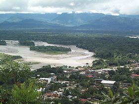
 San Mateo River and Espíritu Santo River (upper right) in Villa Tunari just before their confluence to Chapare River in the east of the town. | |
| Location | |
| Country | Bolivia |
| State | Cochabamba Department |
| District | Chapare Province |
| City | Villa Tunari |
| Physical characteristics | |
| Source | Cordilerra Central de Bolivia |
| • location | Carrasco National Park, Cochabamba Department, Bolivia |
| Length | 173 mi (278 km) |
| Discharge | |
| • location | Ichilo River |

The Chapare River is a river in Bolivia, which is a tributary of the Mamoré River in the Amazon Basin. The river has its source at the confluence of Espíritu Santo River and San Mateo River in the Cochabamba Department at Villa Tunari. It is the main waterway of Chapare Province. The fish Gephyrocharax chaparae is found in and named after the Chapare River.
See also
External links
Wikimedia Commons has media related to Río Chapare.
16°21′S 65°2′W / 16.350°S 65.033°W
