
Gogolin
Gogolin | |
|---|---|
 | |
 Flag  Coat of arms | |
 Gogolin | |
| Coordinates: 50°29′17″N 18°1′26″E / 50.48806°N 18.02389°E | |
| Country | |
| Voivodeship | Opole |
| County | Krapkowice |
| Gmina | Gogolin |
| First mentioned | 1223 |
| Town rights | 1967 |
| Area | |
| • Total | 20.35 km2 (7.86 sq mi) |
| Population (2019-06-30[1]) | |
| • Total | 6,682 |
| • Density | 330/km2 (850/sq mi) |
| Time zone | UTC+1 (CET) |
| • Summer (DST) | UTC+2 (CEST) |
| Postal code | 47-320 |
| Website | http://gogolin.pl |
Gogolin [ɡɔˈɡɔlʲin] is a town in Poland, in Opole Voivodeship, in Krapkowice County. It has 6,682 inhabitants (2019).
Geology and palaeontology
Gogolin gives its name to the Gogolin Formation whose strata were first exposed here.
History


The oldest known mention of Gogolin, under its Old Polish name Gogolino, comes from a 1223 document of Wawrzyniec, bishop of Wrocław.[2] In the 19th century, the exploitation of local limestone deposits began on an industrial scale and first lime kilns were built.[2] Also a train station was built and Gogolin enjoyed railway connections with Opole, Kędzierzyn and Prudnik.[2] Heavy fights of the Silesian Uprising took place nearby in 1921.[2] During World War II the Germans established a forced labour camp for Poles and Jews[3] and two labour camps (E131 and E132) of the Stalag VIII-B/344 prisoner-of-war camp at Łambinowice.[4] About 30 buildings were destroyed in the final stages of the war in 1945.[2]
A high school was established in 1948 and in 1967 Gogolin was granted town rights.[2]
The town is known for its old regional folk song Poszła Karolinka do Gogolina,[5] which is a symbol regional Polish traditions.[6] The song's characters of Karolinka and Karlik are depicted in the town's coat of arms, along with a lime kiln, alluding to the town's traditions.[6] There is also a monument of Karolinka and Karlik in the town centre.
Population
Population in 1782–2005.[7]
|
|
Twin towns – sister cities
See twin towns of Gmina Gogolin.
Gallery
-
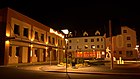 Town center at night with the culture centre on the left
 -
 Mass grave of Polish insurgents of 1921
 -
 Old lime kilns
 -
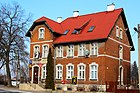 Post office


References
- ^ "Population. Size and structure and vital statistics in Poland by territorial divison in 2019. As of 30th June". stat.gov.pl. Statistics Poland. 2019-10-15. Retrieved 2020-02-14.
- ^ a b c d e f "Atrakcje turystyczne". Urząd Miejski w Gogolinie (in Polish). Retrieved 14 March 2020.
- ^ "Obóz pracy - Zwangsarbeitslager Gogolin". Wirtualny Sztetl (in Polish). Retrieved 14 March 2020.
- ^ "Working Parties". Stalag VIIIB 344 Lamsdorf. Retrieved 14 March 2020.
- ^ "Poszła Karolinka do Gogolina". Urząd Miejski w Gogolinie (in Polish). Retrieved 14 March 2020.
- ^ a b "Herb i flaga miasta Gogolin". Urząd Miejski w Gogolinie (in Polish). Retrieved 14 March 2020.
- ^ Population figures: 1784: [1] – 1830: [2] – 1844: [3] – 1855, 1861: [4] – 1885: [5] - 1900: [6] - 1910: [7] – 1933, 1939: [8] – 1995, 2000, 2005: [9]
External links
- Official town webpage
- Jewish Community in Gogolin on Virtual Shtetl
| Town and seat | | |
|---|---|---|
| Villages | ||
| International | |
|---|---|
| National | |