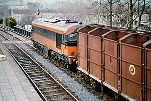
Cahir railway station
 CIE 001 Class 052 departing Cahir station with a westbound fertiliser train on 26 February 1982. | |
| General information | |
| Location | Church Street, Cahir, County Tipperary, E21 KC89 Republic of Ireland |
| Owned by | Iarnród Éireann |
| Operated by | Iarnród Éireann |
| Platforms | 1 |
| Construction | |
| Structure type | At-grade |
| Other information | |
| Station code | CAHIR |
| Fare zone | F |
| Key dates | |
| 1 May 1852 | Station opened |
Limerick–Rosslare | ||||||||||||||||||||||||||||||||||||||||||||||||||||||||||||||||||||||||||||||||||||||||||||||||||||||||||||||||||||||||||||||||||||||||||||||||||||||||||||||||||||||||||||||||||||||||||||||||||||||||||||||||||||||||||||||||||||||||||||||||||||||||||||||||||||||||||||||||||||||||||||||
|---|---|---|---|---|---|---|---|---|---|---|---|---|---|---|---|---|---|---|---|---|---|---|---|---|---|---|---|---|---|---|---|---|---|---|---|---|---|---|---|---|---|---|---|---|---|---|---|---|---|---|---|---|---|---|---|---|---|---|---|---|---|---|---|---|---|---|---|---|---|---|---|---|---|---|---|---|---|---|---|---|---|---|---|---|---|---|---|---|---|---|---|---|---|---|---|---|---|---|---|---|---|---|---|---|---|---|---|---|---|---|---|---|---|---|---|---|---|---|---|---|---|---|---|---|---|---|---|---|---|---|---|---|---|---|---|---|---|---|---|---|---|---|---|---|---|---|---|---|---|---|---|---|---|---|---|---|---|---|---|---|---|---|---|---|---|---|---|---|---|---|---|---|---|---|---|---|---|---|---|---|---|---|---|---|---|---|---|---|---|---|---|---|---|---|---|---|---|---|---|---|---|---|---|---|---|---|---|---|---|---|---|---|---|---|---|---|---|---|---|---|---|---|---|---|---|---|---|---|---|---|---|---|---|---|---|---|---|---|---|---|---|---|---|---|---|---|---|---|---|---|---|---|---|---|---|---|---|---|---|---|---|---|---|---|---|---|---|---|---|---|---|---|---|---|---|---|---|---|---|---|---|---|---|---|---|---|
| ||||||||||||||||||||||||||||||||||||||||||||||||||||||||||||||||||||||||||||||||||||||||||||||||||||||||||||||||||||||||||||||||||||||||||||||||||||||||||||||||||||||||||||||||||||||||||||||||||||||||||||||||||||||||||||||||||||||||||||||||||||||||||||||||||||||||||||||||||||||||||||||
Cahir railway station serves the town of Cahir, County Tipperary in Ireland.
It has a weekday passenger service of two trains to Limerick Junction and two to Waterford. There is no Sunday service.[1] Until 19 January 2013 (inclusive) there were three trains each way. However, the late-morning Waterford to Limerick Junction and early-afternoon Limerick Junction to Waterford trains are now discontinued.[2]
Passengers should change at Limerick Junction for connections to Limerick, Cork, Tralee, Galway and Dublin.
The station is unstaffed and the platform is accessible via a ramp.[3]
History
The station opened on 1 May 1852.[4]
See also
References
- ^ "Archived copy" (PDF). Archived from the original (PDF) on 2013-01-16. Retrieved 2013-01-11.
{{cite web}}: CS1 maint: archived copy as title (link) - ^ "Archived copy". Archived from the original on 2013-01-24. Retrieved 2013-01-21.
{{cite web}}: CS1 maint: archived copy as title (link) - ^ http://www.irishrail.ie/index.jsp?p=120&n=151 Archived 2012-08-19 at the Wayback Machine Irish Rail Accessiblity Guide
- ^ "Cahir station" (PDF). Railscot - Irish Railways. Retrieved 2007-09-07.
External links
- Irish Rail Cahir Station Website
- National Inventory of Industrial Heritage - Cahir Station
- South Tipperary Rail & Bus Website
Template:IERail start
|-
| rowspan="1" style="vertical-align: middle; text-align:center; border-left: 0px none; border-right: 1px #aaa solid; border-top: 1px #aaa solid; border-bottom:0px none;"| Tipperary
| style="background:#FFA500; color:inherit; border-left: 0px none; border-right: 0px none; border-top:1px #aaa solid; border-bottom:0px none;" |
| rowspan="1" style="vertical-align: middle; text-align: center; border-left: 1px #aaa solid; border-right: 1px #aaa solid; border-top:solid 1px #aaa; border-bottom:0px none;" | InterCity
Limerick-Waterford
| style="background:#FFA500; color:inherit; border-left: 0px none; border-right: 0px none; border-top:1px #aaa solid; border-bottom:0px none;" |
| rowspan="1" style="vertical-align: middle; text-align:center; border-left: 1px #aaa solid; border-right: 0px none; border-top: 1px #aaa solid; border-bottom:0px none;"|Clonmel
|}
52°22′40″N 7°55′22″W / 52.377731°N 7.922710°W
