
Héry-sur-Alby
Héry-sur-Alby | |
|---|---|
 Héry-sur-Alby | |
Location of Héry-sur-Alby  | |
 Héry-sur-Alby  Héry-sur-Alby | |
| Coordinates: 45°47′52″N 6°00′50″E / 45.7978°N 6.0139°E | |
| Country | France |
| Region | Auvergne-Rhône-Alpes |
| Department | Haute-Savoie |
| Arrondissement | Annecy |
| Canton | Rumilly |
| Intercommunality | CA Grand Annecy |
| Government | |
| • Mayor (2020–2026) | Jacques Archinard |
| Area 1 | 7.33 km2 (2.83 sq mi) |
| Population (2021)[1] | 967 |
| • Density | 130/km2 (340/sq mi) |
| Time zone | UTC+01:00 (CET) |
| • Summer (DST) | UTC+02:00 (CEST) |
| INSEE/Postal code | 74142 /74540 |
| Elevation | 398–702 m (1,306–2,303 ft) |
| 1 French Land Register data, which excludes lakes, ponds, glaciers > 1 km2 (0.386 sq mi or 247 acres) and river estuaries. | |
Héry-sur-Alby is a commune in the Haute-Savoie department in the Auvergne-Rhône-Alpes region in south-eastern France.
Geography
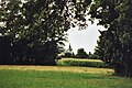
The Chéran forms the commune's eastern border.
Gallery
-
-

-
 Notre-Dame-de-la-Nativité church in Héry-sur-Alby.
 -
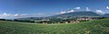
 Sunset on the snowy Parmelan, seen from Héry-sur-Alby.
 -
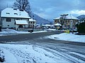 Snowy streets in Héry-sur-Alby.
 -
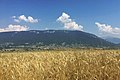 The Semnoz seen from a wheat field on top of Héry-sur-Alby's hill.
 -


See also
References
- ^ "Populations légales 2021" (in French). The National Institute of Statistics and Economic Studies. 28 December 2023.
Wikimedia Commons has media related to Héry-sur-Alby.
| International | |
|---|---|
| National | |
| Other | |
This Haute-Savoie geographical article is a stub. You can help Wikipedia by expanding it. |